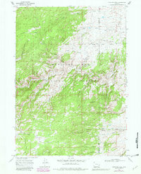
1968 Map of Fletcher Park
USGS Topo · Published 1981About this map
Medicine Bow National Forest dominates this landscape along the border of Albany and Platte Counties, capturing a remote pocket of the Laramie Mountains as it appeared in the late 1960s and early 1980s. The topography is defined by high plateaus and sharp descents, notably around Van Ortwick Hill and the distinctive geological formations of Indian Head Rock and Chimney Rock.
Find a feature on this map
32 named features on this map. Tap any name to fly to it.
Don’t see what you’re looking for? This feature index may not catch every label — zoom into the map to look around manually.
Map Details
Editions of this 1968 Fletcher Park Map
3 editions found
Other maps of this area

1943 · Esterbrook
USGS Topo · 1:62,500

1945 · Esterbrook
USGS Topo · 1:62,500

1950 · Cottonwood Falls
USGS Topo · 1:24,000

1951 · Cottonwood Falls
USGS Topo · 1:24,000

1953 · Hightower SW
USGS Topo · 1:24,000

1953 · Johnson Mountain
USGS Topo · 1:24,000

1954 · Torrington
USGS Topo · 1:250,000

1958 · Torrington
USGS Topo · 1:250,000

1968 · Davidson Flats
USGS Topo · 1:24,000
1968 · Reese Mountain
USGS Topo · 1:24,000