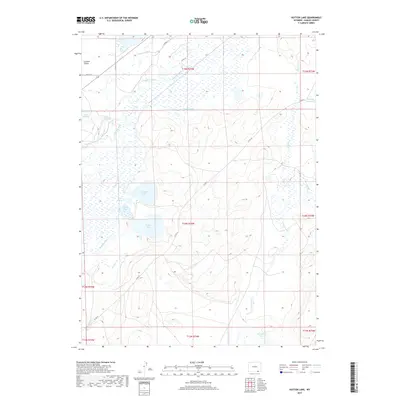
2017 Map of Hutton Lake
USGS Topo · Published 2017About this map
The Laramie Plains are defined here by a sophisticated network of water management features designed to sustain this high-altitude basin. A series of irrigation works, including the Monolith Ditch, Pioneer Lateral, and Dowlin Ditch, redirect flows from the Laramie River across the landscape. This water supports a chain of lakes and reservoirs such as Hutton Lake, Creighton Lake, and Lake George. The concentration of these aquatic features in an otherwise arid environment underscores the historical importance of water rights and land use in Albany County. Traces of local roads, such as Co RD 34, provide a modern framework to the township and range survey lines that have partitioned this ranching country for over a century.
Find a feature on this map
30 named features on this map. Tap any name to fly to it.
Don’t see what you’re looking for? This feature index may not catch every label — zoom into the map to look around manually.
Map Details
Editions of this 2017 Hutton Lake Map
This is the sole edition of this map. No revisions or reprints were ever made.
Other maps of this area

1895 · Laramie
USGS Topo · 1:125,000

1902 · Laramie
USGS Topo · 1:125,000

1905 · Laramie
USGS Topo · 1:125,000

1906 · Laramie
USGS Topo · 1:125,000

1908 · Laramie
USGS Topo · 1:125,000

1954 · Cheyenne
USGS Topo · 1:250,000

1958 · Cheyenne
USGS Topo · 1:250,000
1962 · Miller
USGS Topo · 1:24,000
1963 · Laramie
USGS Topo · 1:24,000
1963 · Caldwell Lake
USGS Topo · 1:24,000