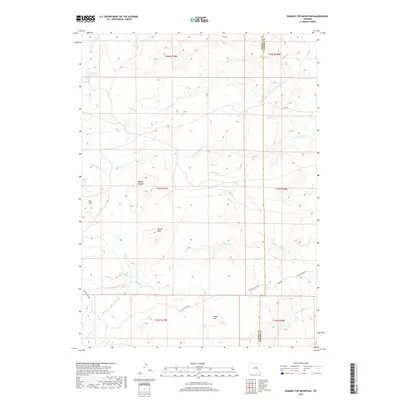
2017 Map of Ragged Top Mountain
USGS Topo · Published 2017About this map
Ragged Top Mtn and Powell Mtn anchor this high-elevation landscape along the border of Albany and Laramie counties. The terrain is defined by a dendritic drainage network feeding the various branches of the Horse Creek system, including the N Fork Horse Cr and S Fork Horse Cr. Human impact is visible through a handful of high-country routes such as Roger Canyon Rd and Fisher Canyon Rd, which skirt the lower slopes of Horse Mtn. Water management in this arid environment is represented by the Alvie Number One Reservoir in the northwest. The presence of Schoolhouse Cr suggests the historical location of rural education centers that once served the ranching families of these uplands. This 2017 survey provides a clear look at the contemporary land divisions and the enduring character of the Laramie Range foothills.
Find a feature on this map
22 named features on this map. Tap any name to fly to it.
Don’t see what you’re looking for? This feature index may not catch every label — zoom into the map to look around manually.
Map Details
Editions of this 2017 Ragged Top Mountain Map
This is the sole edition of this map. No revisions or reprints were ever made.
Other maps of this area

1905 · Sherman
USGS Topo · 1:125,000

1948 · Ragged Top Mountain
USGS Topo · 1:62,500

1950 · Ragged Top Mountain
USGS Topo · 1:62,500

1954 · Cheyenne
USGS Topo · 1:250,000

1955 · Baldy Mountain
USGS Topo · 1:24,000

1955 · Goat Mountain
USGS Topo · 1:24,000

1958 · Cheyenne
USGS Topo · 1:250,000

1962 · Horse Creek
USGS Topo · 1:24,000

1962 · Farthing
USGS Topo · 1:24,000
1962 · Islay
USGS Topo · 1:24,000