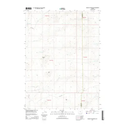
2015 Map of Ragged Top Mountain
USGS Topo · Published 2015About this map
Ragged Top Mtn and Powell Mtn anchor the high-country topography of the Laramie Range as it appeared in 2015. This survey documents a complex drainage system where the headwaters of the Horse Creek watershed emerge, including N Fork Horse Cr and S Fork Horse Cr. The presence of Schoolhouse Cr and names like Alice Number One Reservoir point to the area's history of ranching and land management. Straddling the boundary between Albany and Laramie counties, the map shows a landscape defined by seasonal waterways like Ricker Cr and Mill Cr and accessible via rugged paths such as Roger Canyon Rd and King Mountain Rd.
Find a feature on this map
21 named features on this map. Tap any name to fly to it.
Don’t see what you’re looking for? This feature index may not catch every label — zoom into the map to look around manually.
Map Details
Editions of this 2015 Ragged Top Mountain Map
This is the sole edition of this map. No revisions or reprints were ever made.
Other maps of this area

1905 · Sherman
USGS Topo · 1:125,000

1948 · Ragged Top Mountain
USGS Topo · 1:62,500

1950 · Ragged Top Mountain
USGS Topo · 1:62,500

1954 · Cheyenne
USGS Topo · 1:250,000

1955 · Baldy Mountain
USGS Topo · 1:24,000

1955 · Goat Mountain
USGS Topo · 1:24,000

1958 · Cheyenne
USGS Topo · 1:250,000

1962 · Horse Creek
USGS Topo · 1:24,000

1962 · Farthing
USGS Topo · 1:24,000
1962 · Islay
USGS Topo · 1:24,000