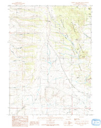
1987 Map of Sherman Mountains West
USGS Topo · Published 1987About this map
The Ames Monument stands as a prominent landmark in this high-altitude landscape, marking a significant point of historical interest near the southern edge of the Medicine Bow National Forest. This 1987 survey captures the rugged hydrology of the Sherman Mountains, where numerous drainages like Dale Creek and South Crow Creek carve through the terrain. The presence of an Old Railroad Grade running parallel to Pump Creek indicates the enduring footprint of early transcontinental transportation infrastructure through these mountain passes.
Find a feature on this map
34 named features on this map. Tap any name to fly to it.
Don’t see what you’re looking for? This feature index may not catch every label — zoom into the map to look around manually.
Map Details
Editions of this 1987 Sherman Mountains West Map
2 editions found
Other maps of this area

1895 · Laramie
USGS Topo · 1:125,000

1902 · Laramie
USGS Topo · 1:125,000

1905 · Sherman
USGS Topo · 1:125,000

1905 · Laramie
USGS Topo · 1:125,000

1906 · Laramie
USGS Topo · 1:125,000

1908 · Laramie
USGS Topo · 1:125,000

1948 · Sherman Mountains
USGS Topo · 1:62,500

1948 · Ragged Top Mountain
USGS Topo · 1:62,500

1950 · Ragged Top Mountain
USGS Topo · 1:62,500

1950 · Sherman Mountains
USGS Topo · 1:62,500