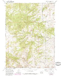
1968 Map of Reese Mountain
USGS Topo · Published 1985About this map
The Medicine Bow National Forest dominates this section of the Wyoming landscape, where the Laramie River carves through the terrain as it flows past Reese Mountain. This 1968 survey, updated in the mid-1980s, reveals a network of canyons and draws that define the local topography, including Luman Canyon and Ringrose Canyon. The presence of the Marble Quarry near Scranton Road indicates the industrial activity of the era, while named locations like Collins and Shapley point to the human geography of the region.
Find a feature on this map
42 named features on this map. Tap any name to fly to it.
Don’t see what you’re looking for? This feature index may not catch every label — zoom into the map to look around manually.
Map Details
Editions of this 1968 Reese Mountain Map
2 editions found
Other maps of this area

1953 · Squaw Rock
USGS Topo · 1:24,000

1953 · Hightower SW
USGS Topo · 1:24,000

1953 · Johnson Mountain
USGS Topo · 1:24,000

1954 · Torrington
USGS Topo · 1:250,000

1954 · Cheyenne
USGS Topo · 1:250,000

1955 · Moonshine Peak
USGS Topo · 1:24,000

1955 · Bull Camp Peak
USGS Topo · 1:24,000

1958 · Cheyenne
USGS Topo · 1:250,000

1958 · Torrington
USGS Topo · 1:250,000

1968 · Davidson Flats
USGS Topo · 1:24,000