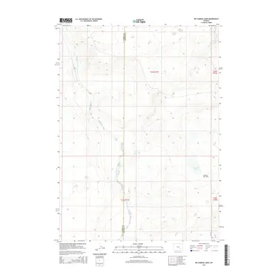
2015 Map of Big Charlie Lakes
USGS Topo · Published 2015About this map
The Little Medicine Bow River winds through the high plains of the Wyoming interior, straddling the border between Carbon and Albany counties. This landscape is defined by its drainage patterns, with intermittent waterways like Spring Cr and the topographical depression of Johnson Flat Draw shaping the terrain. The central hydrology is anchored by the Big Charlie Lakes, a cluster of water bodies situated in the southeastern portion of the quadrangle. Human infrastructure is notably sparse in this cattle-country environment, represented primarily by the solitary stretch of Marshall Rd in the southeast corner. The map illustrates a strictly rural Wyoming character where land is divided by the Public Land Survey System into townships like t26n r77w and t25n r76w, reflecting a continuation of traditional ranching and open-range land use into the 21st century.
Find a feature on this map
10 named features on this map. Tap any name to fly to it.
Don’t see what you’re looking for? This feature index may not catch every label — zoom into the map to look around manually.
Map Details
Editions of this 2015 Big Charlie Lakes Map
This is the sole edition of this map. No revisions or reprints were ever made.
Other maps of this area

1954 · Torrington
USGS Topo · 1:250,000

1955 · Casper
USGS Topo · 1:250,000

1958 · Casper
USGS Topo · 1:250,000

1958 · Torrington
USGS Topo · 1:250,000

1959 · Moss Agate Reservoir
USGS Topo · 1:24,000

1959 · Chalk Hills
USGS Topo · 1:24,000
1961 · Walker Draw SE
USGS Topo · 1:24,000

1961 · T B Ranch
USGS Topo · 1:24,000
1961 · Big Charlie Lakes
USGS Topo · 1:24,000
1961 · Walker Draw NW
USGS Topo · 1:24,000