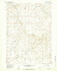
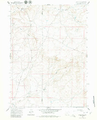
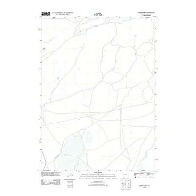
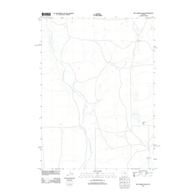
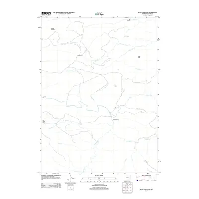
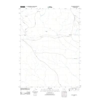
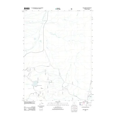
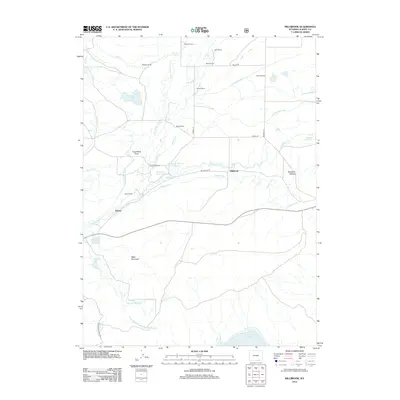
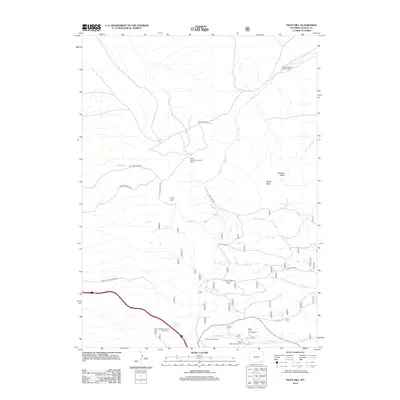
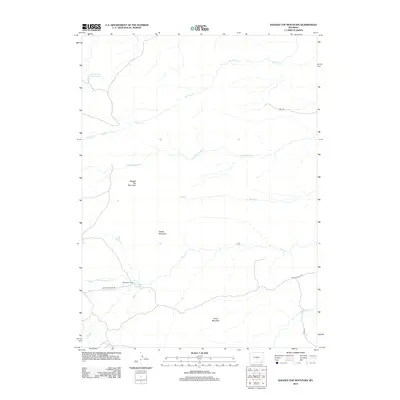
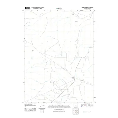
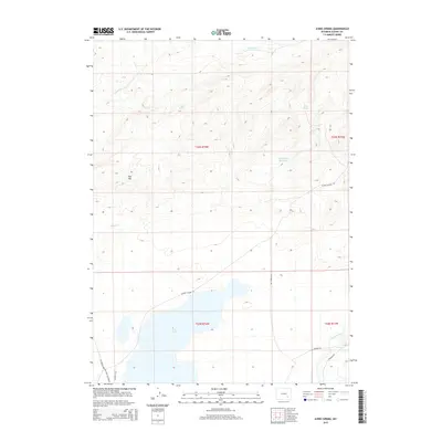
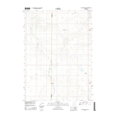
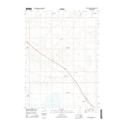
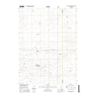
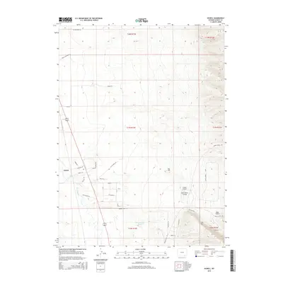
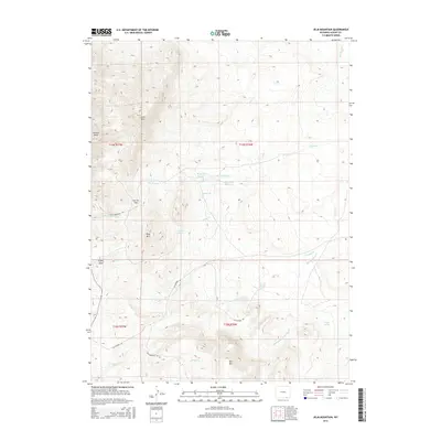
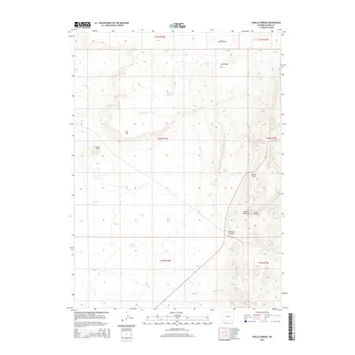
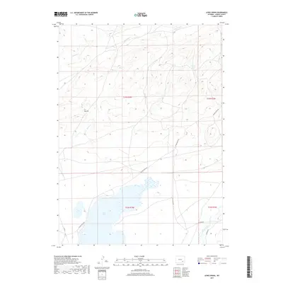
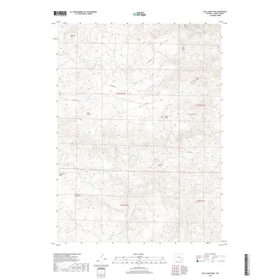
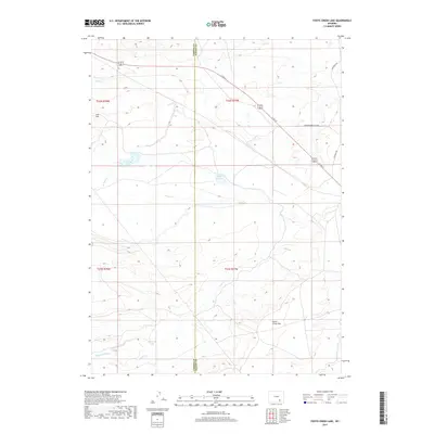
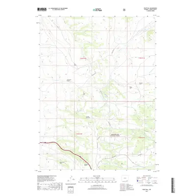
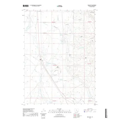
1959 Map of Chalk Hills
USGS Topo · Published 1962About this map
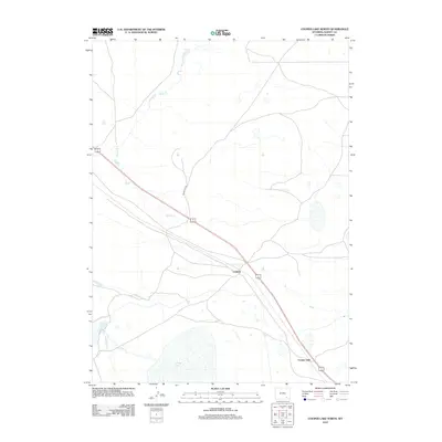
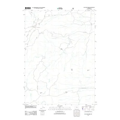
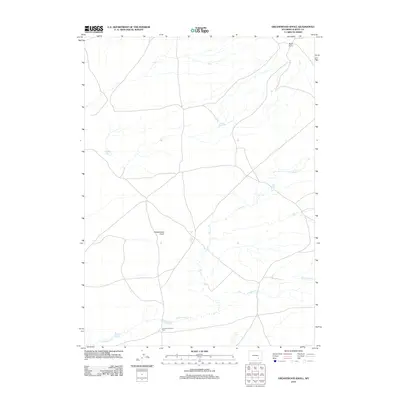
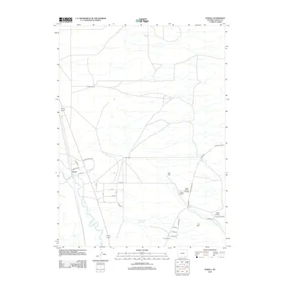
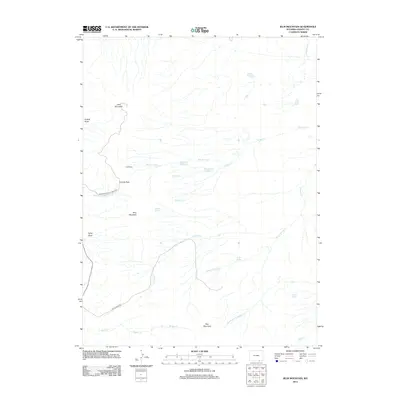
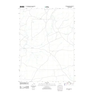
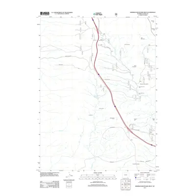
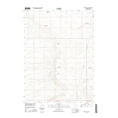
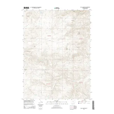
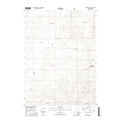
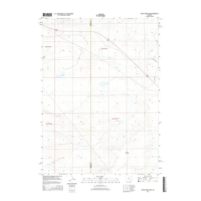
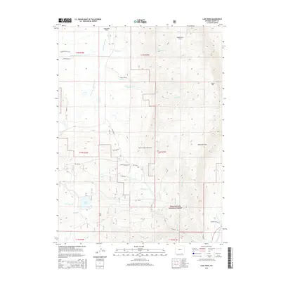
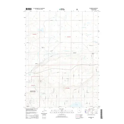
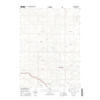
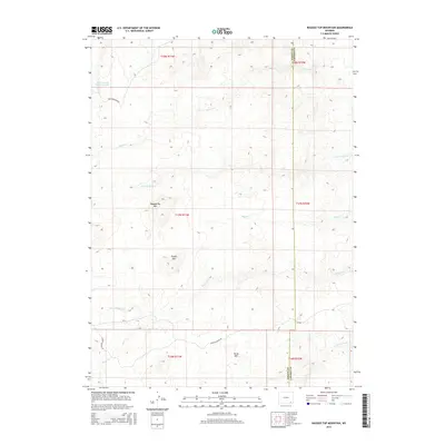
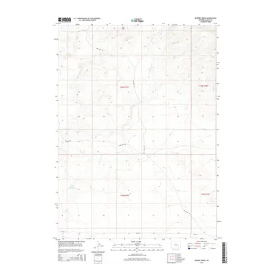
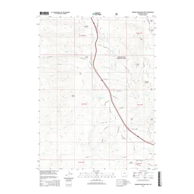
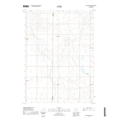
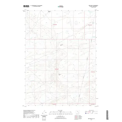
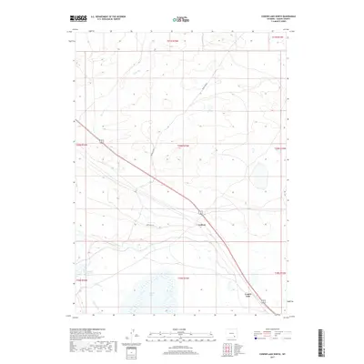
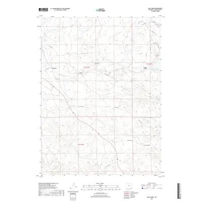
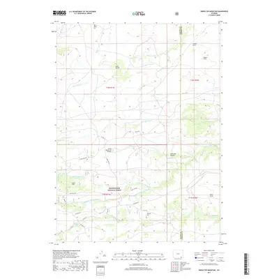
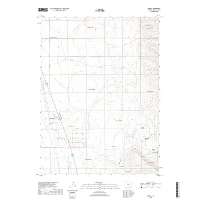
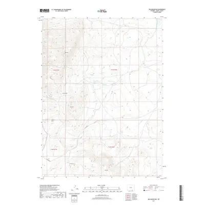
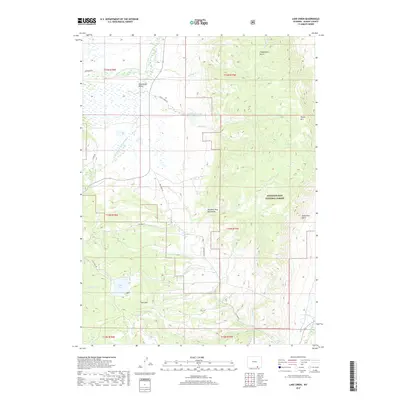
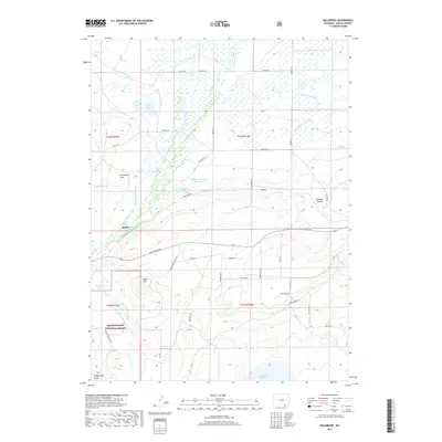
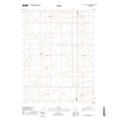
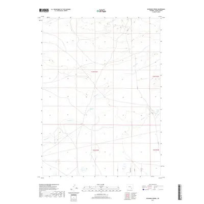
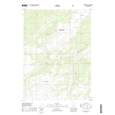
The Chalk Hills and their surrounding high-plains landscape are documented here during the late 1950s, straddling the border between Carbon and Albany counties. This region of Wyoming is defined by the winding course of the Little Medicine Bow River and its South Fork, which carve through the high terrain. Local transportation is anchored by the Old Casper Medicine Bow Road, a vital route connecting the scattered ranching interests of the era. Evidence of early habitation and land use is preserved in labels for the Higghson Homestead and Heward Ranch. A particularly unique geological feature noted on this survey is the Petrified Forest Area, located in the western portion of the quadrangle. The map also records specialized infrastructure such as a remote Landing Field and several named drainages including Chalk Draw and Slate Draw.
Find a feature on this map
14 named features on this map. Tap any name to fly to it.
Don’t see what you’re looking for? This feature index may not catch every label — zoom into the map to look around manually.
Map Details
Editions of this 1959 Chalk Hills Map
3 editions found
Historical Maps of Albany County Through Time
413 maps found

1948 Ragged Top Mountain
Albany County, WY

1948 Sherman Mountains
Albany County, WY

1950 Ragged Top Mountain
Albany County, WY

1950 Sherman Mountains
Albany County, WY

1955 Ayres Spring
Albany County, WY

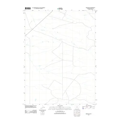
1955 Baldy Mountain
Albany County, WY

1955 Big Judson
Albany County, WY

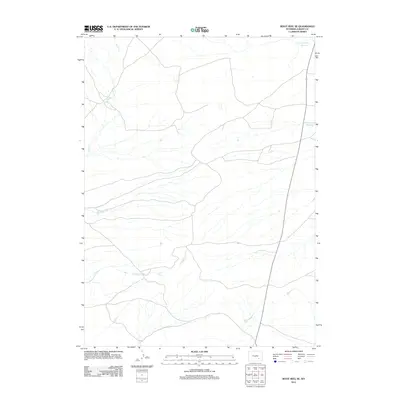
1955 Bluegrass Wells
Albany County, WY

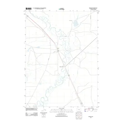
1955 Bosler
Albany County, WY

1955 Bosler SE
Albany County, WY

1955 Bull Camp Peak
Albany County, WY

1955 Cannonball Cut
Albany County, WY

1955 Cooper Lake North
Albany County, WY

1955 Cooper Lake South
Albany County, WY

1955 Dodge Ranch
Albany County, WY

1955 Goat Mountain
Albany County, WY

1955 Guide Rock
Albany County, WY

1955 Indian Guide
Albany County, WY

1955 Lake Ione
Albany County, WY

1955 Mc Gill Lakes
Albany County, WY

1955 Moonshine Peak
Albany County, WY

1955 Pine Tree Ridge
Albany County, WY

1955 Poe Mountain
Albany County, WY

1955 Sevenmile Spring
Albany County, WY

1955 Sheep Rock
Albany County, WY

1955 Sybille Springs
Albany County, WY

1955 Wilcox
Albany County, WY

1958 Bengough Hill
Albany County, WY

1958 Pierce Reservoir
Albany County, WY

1959 Chalk Hills
Albany County, WY

1961 Big Charlie Lakes
Albany County, WY

1961 Foxpark
Albany County, WY

1961 Horatio Rock
Albany County, WY

1961 Keystone
Albany County, WY

1961 Lake Owen
Albany County, WY

1961 Medicine Bow Peak
Albany County, WY

1961 Rex Lake
Albany County, WY

1961 Strouss Hill
Albany County, WY

1961 Walker Draw SE
Albany County, WY

1961 Woods Landing
Albany County, WY

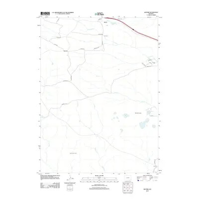
1962 Millbrook
Albany County, WY

1962 Miller
Albany County, WY

1963 Alsop Lake
Albany County, WY

1963 Bamforth Lake
Albany County, WY

1963 Best Ranch
Albany County, WY

1963 Caldwell Lake
Albany County, WY

1963 Downey Lakes
Albany County, WY

1963 Howell
Albany County, WY

1963 Hutton Lake
Albany County, WY

1963 James Lake
Albany County, WY

1963 Jelm Mountain
Albany County, WY

1963 Johnson Ranch
Albany County, WY

1963 Laramie SW
Albany County, WY

1963 Red Buttes
Albany County, WY

1963 Sodergreen Lake
Albany County, WY

1964 Marshall
Albany County, WY

1964 Pass Creek
Albany County, WY

1964 Toltec
Albany County, WY

1968 Boot Heel
Albany County, WY

1968 Boot Heel SE
Albany County, WY

1968 Cottonwood Creek
Albany County, WY

1968 Cow Creek Mountain
Albany County, WY

1968 Davidson Flats
Albany County, WY

1968 Fletcher Park
Albany County, WY

1968 Garrett
Albany County, WY

1968 Greasewood Knoll
Albany County, WY

1968 Pinto Creek
Albany County, WY

1968 Reese Mountain
Albany County, WY

1968 Rogers Creek
Albany County, WY

1968 South Mountain
Albany County, WY

1971 Aurora Lake
Albany County, WY

1971 Foote Creek Lake
Albany County, WY

1981 Laramie Peak
Albany County, WY

1985 Harris Park
Albany County, WY

1987 Buford
Albany County, WY

1987 Dale Creek
Albany County, WY

1987 Green Top Mountain
Albany County, WY

1987 King Mountain
Albany County, WY

1987 Pilot Hill
Albany County, WY

1987 Ragged Top Mountain
Albany County, WY

1987 Sherman Mountains East
Albany County, WY

1987 Sherman Mountains West
Albany County, WY

1992 Cottonwood Creek
Albany County, WY

1992 Cow Creek Mtn
Albany County, WY

1992 Davidson Flats
Albany County, WY

1992 Fletcher Park
Albany County, WY

1992 Foxpark
Albany County, WY

1992 Green Top Mountain
Albany County, WY

1992 Harris Park
Albany County, WY

1992 Keystone
Albany County, WY

1992 Lake Owen
Albany County, WY

1992 Marshall
Albany County, WY

1992 Medicine Bow Peak
Albany County, WY

1992 Millbrook
Albany County, WY

1992 Pilot Hill
Albany County, WY

1992 Reese Mountain
Albany County, WY

1992 Rex Lake
Albany County, WY

1992 Sherman Mountains East
Albany County, WY

1992 Sherman Mountains West
Albany County, WY

1992 Sodergreen Lake
Albany County, WY

1992 South Mountain
Albany County, WY

1992 Strouss Hill
Albany County, WY

1992 Toltec
Albany County, WY

1992 Woods Landing
Albany County, WY
2012 Alsop Lake
Albany County, WY
2012 Aurora Lake
Albany County, WY
2012 Ayres Spring
Albany County, WY
2012 Baldy Mountain
Albany County, WY
2012 Bamforth Lake
Albany County, WY
2012 Bengough Hill
Albany County, WY

2012 Best Ranch
Albany County, WY
2012 Big Charlie Lakes
Albany County, WY
2012 Big Judson
Albany County, WY
2012 Bluegrass Wells
Albany County, WY
2012 Boot Heel
Albany County, WY
2012 Boot Heel SE
Albany County, WY
2012 Bosler
Albany County, WY
2012 Bosler SE
Albany County, WY
2012 Buford
Albany County, WY
2012 Bull Camp Peak
Albany County, WY
2012 Caldwell Lake
Albany County, WY
2012 Cannonball Cut
Albany County, WY
2012 Chalk Hills
Albany County, WY
2012 Cooper Lake North
Albany County, WY
2012 Cooper Lake South
Albany County, WY
2012 Cottonwood Creek
Albany County, WY
2012 Cow Creek Mountain
Albany County, WY
2012 Dale Creek
Albany County, WY
2012 Davidson Flats
Albany County, WY
2012 Dodge Ranch
Albany County, WY
2012 Downey Lakes
Albany County, WY
2012 Fletcher Park
Albany County, WY
2012 Foote Creek Lake
Albany County, WY

2012 Foxpark
Albany County, WY
2012 Garrett
Albany County, WY
2012 Goat Mountain
Albany County, WY
2012 Greasewood Knoll
Albany County, WY

2012 Green Top Mountain
Albany County, WY
2012 Guide Rock
Albany County, WY
2012 Harris Park
Albany County, WY
2012 Horatio Rock
Albany County, WY
2012 Howell
Albany County, WY
2012 Hutton Lake
Albany County, WY
2012 Indian Guide
Albany County, WY
2012 James Lake
Albany County, WY
2012 Jelm Mountain
Albany County, WY
2012 Johnson Ranch
Albany County, WY

2012 Keystone
Albany County, WY
2012 King Mountain
Albany County, WY
2012 Lake Ione
Albany County, WY
2012 Lake Owen
Albany County, WY

2012 Laramie SW
Albany County, WY
2012 Marshall
Albany County, WY
2012 McGill Lakes
Albany County, WY
2012 Medicine Bow Peak
Albany County, WY
2012 Millbrook
Albany County, WY
2012 Miller
Albany County, WY
2012 Moonshine Peak
Albany County, WY
2012 Pass Creek
Albany County, WY

2012 Pierce Reservoir
Albany County, WY
2012 Pilot Hill
Albany County, WY
2012 Pine Tree Ridge
Albany County, WY
2012 Pinto Creek
Albany County, WY
2012 Poe Mountain
Albany County, WY
2012 Ragged Top Mountain
Albany County, WY
2012 Red Buttes
Albany County, WY
2012 Reese Mountain
Albany County, WY
2012 Rex Lake
Albany County, WY
2012 Rogers Creek
Albany County, WY
2012 Sevenmile Spring
Albany County, WY
2012 Sheep Rock
Albany County, WY
2012 Sherman Mountains East
Albany County, WY
2012 Sherman Mountains West
Albany County, WY
2012 Sodergreen Lake
Albany County, WY
2012 South Mountain
Albany County, WY
2012 Strouss Hill
Albany County, WY
2012 Sybille Springs
Albany County, WY

2012 Toltec
Albany County, WY
2012 Walker Draw SE
Albany County, WY

2012 Wilcox
Albany County, WY

2012 Woods Landing
Albany County, WY
2015 Alsop Lake
Albany County, WY
2015 Aurora Lake
Albany County, WY
2015 Ayres Spring
Albany County, WY
2015 Baldy Mountain
Albany County, WY
2015 Bamforth Lake
Albany County, WY
2015 Bengough Hill
Albany County, WY

2015 Best Ranch
Albany County, WY
2015 Big Charlie Lakes
Albany County, WY
2015 Big Judson
Albany County, WY
2015 Bluegrass Wells
Albany County, WY
2015 Boot Heel
Albany County, WY
2015 Boot Heel SE
Albany County, WY
2015 Bosler
Albany County, WY
2015 Bosler SE
Albany County, WY
2015 Buford
Albany County, WY
2015 Bull Camp Peak
Albany County, WY
2015 Caldwell Lake
Albany County, WY
2015 Cannonball Cut
Albany County, WY
2015 Chalk Hills
Albany County, WY
2015 Cooper Lake North
Albany County, WY
2015 Cooper Lake South
Albany County, WY
2015 Cottonwood Creek
Albany County, WY
2015 Cow Creek Mountain
Albany County, WY

2015 Dale Creek
Albany County, WY
2015 Davidson Flats
Albany County, WY
2015 Dodge Ranch
Albany County, WY
2015 Downey Lakes
Albany County, WY
2015 Fletcher Park
Albany County, WY
2015 Foote Creek Lake
Albany County, WY

2015 Foxpark
Albany County, WY
2015 Garrett
Albany County, WY
2015 Goat Mountain
Albany County, WY
2015 Greasewood Knoll
Albany County, WY
2015 Green Top Mountain
Albany County, WY
2015 Guide Rock
Albany County, WY
2015 Harris Park
Albany County, WY
2015 Horatio Rock
Albany County, WY
2015 Howell
Albany County, WY
2015 Hutton Lake
Albany County, WY
2015 Indian Guide
Albany County, WY
2015 James Lake
Albany County, WY
2015 Jelm Mountain
Albany County, WY
2015 Johnson Ranch
Albany County, WY

2015 Keystone
Albany County, WY
2015 King Mountain
Albany County, WY
2015 Lake Ione
Albany County, WY
2015 Lake Owen
Albany County, WY

2015 Laramie SW
Albany County, WY
2015 Marshall
Albany County, WY
2015 McGill Lakes
Albany County, WY
2015 Medicine Bow Peak
Albany County, WY
2015 Millbrook
Albany County, WY
2015 Miller
Albany County, WY
2015 Moonshine Peak
Albany County, WY
2015 Pass Creek
Albany County, WY

2015 Pierce Reservoir
Albany County, WY
2015 Pilot Hill
Albany County, WY
2015 Pine Tree Ridge
Albany County, WY
2015 Pinto Creek
Albany County, WY
2015 Poe Mountain
Albany County, WY
2015 Ragged Top Mountain
Albany County, WY
2015 Red Buttes
Albany County, WY
2015 Reese Mountain
Albany County, WY
2015 Rex Lake
Albany County, WY
2015 Rogers Creek
Albany County, WY
2015 Sevenmile Spring
Albany County, WY
2015 Sheep Rock
Albany County, WY
2015 Sherman Mountains East
Albany County, WY
2015 Sherman Mountains West
Albany County, WY
2015 Sodergreen Lake
Albany County, WY
2015 South Mountain
Albany County, WY
2015 Strouss Hill
Albany County, WY
2015 Sybille Springs
Albany County, WY

2015 Toltec
Albany County, WY
2015 Walker Draw SE
Albany County, WY

2015 Wilcox
Albany County, WY

2015 Woods Landing
Albany County, WY
2017 Alsop Lake
Albany County, WY
2017 Aurora Lake
Albany County, WY
2017 Ayres Spring
Albany County, WY
2017 Baldy Mountain
Albany County, WY
2017 Bamforth Lake
Albany County, WY
2017 Bengough Hill
Albany County, WY

2017 Best Ranch
Albany County, WY
2017 Big Charlie Lakes
Albany County, WY
2017 Big Judson
Albany County, WY
2017 Bluegrass Wells
Albany County, WY
2017 Boot Heel
Albany County, WY
2017 Boot Heel SE
Albany County, WY
2017 Bosler
Albany County, WY
2017 Bosler SE
Albany County, WY
2017 Buford
Albany County, WY
2017 Bull Camp Peak
Albany County, WY
2017 Caldwell Lake
Albany County, WY
2017 Cannonball Cut
Albany County, WY
2017 Chalk Hills
Albany County, WY
2017 Cooper Lake North
Albany County, WY
2017 Cooper Lake South
Albany County, WY
2017 Cottonwood Creek
Albany County, WY
2017 Cow Creek Mountain
Albany County, WY
2017 Dale Creek
Albany County, WY

2017 Davidson Flats
Albany County, WY
2017 Dodge Ranch
Albany County, WY
2017 Downey Lakes
Albany County, WY
2017 Fletcher Park
Albany County, WY
2017 Foote Creek Lake
Albany County, WY

2017 Foxpark
Albany County, WY
2017 Garrett
Albany County, WY
2017 Goat Mountain
Albany County, WY
2017 Greasewood Knoll
Albany County, WY
2017 Green Top Mountain
Albany County, WY
2017 Guide Rock
Albany County, WY
2017 Harris Park
Albany County, WY
2017 Horatio Rock
Albany County, WY
2017 Howell
Albany County, WY
2017 Hutton Lake
Albany County, WY
2017 Indian Guide
Albany County, WY
2017 James Lake
Albany County, WY
2017 Jelm Mountain
Albany County, WY
2017 Johnson Ranch
Albany County, WY

2017 Keystone
Albany County, WY
2017 King Mountain
Albany County, WY
2017 Lake Ione
Albany County, WY
2017 Lake Owen
Albany County, WY

2017 Laramie SW
Albany County, WY
2017 Marshall
Albany County, WY
2017 McGill Lakes
Albany County, WY
2017 Medicine Bow Peak
Albany County, WY
2017 Millbrook
Albany County, WY
2017 Miller
Albany County, WY
2017 Moonshine Peak
Albany County, WY
2017 Pass Creek
Albany County, WY

2017 Pierce Reservoir
Albany County, WY
2017 Pilot Hill
Albany County, WY
2017 Pine Tree Ridge
Albany County, WY
2017 Pinto Creek
Albany County, WY
2017 Poe Mountain
Albany County, WY
2017 Ragged Top Mountain
Albany County, WY
2017 Reese Mountain
Albany County, WY
2017 Rex Lake
Albany County, WY
2017 Rogers Creek
Albany County, WY
2017 Sevenmile Spring
Albany County, WY
2017 Sheep Rock
Albany County, WY
2017 Sherman Mountains East
Albany County, WY
2017 Sherman Mountains West
Albany County, WY
2017 South Mountain
Albany County, WY
2017 Strouss Hill
Albany County, WY
2017 Sybille Springs
Albany County, WY

2017 Toltec
Albany County, WY
2017 Walker Draw SE
Albany County, WY

2017 Wilcox
Albany County, WY

2017 Woods Landing
Albany County, WY
2018 Red Buttes
Albany County, WY
2018 Sodergreen Lake
Albany County, WY

2021 Alsop Lake
Albany County, WY

2021 Aurora Lake
Albany County, WY

2021 Ayres Spring
Albany County, WY

2021 Baldy Mountain
Albany County, WY

2021 Bamforth Lake
Albany County, WY

2021 Bengough Hill
Albany County, WY

2021 Best Ranch
Albany County, WY

2021 Big Charlie Lakes
Albany County, WY

2021 Big Judson
Albany County, WY

2021 Bluegrass Wells
Albany County, WY

2021 Boot Heel
Albany County, WY

2021 Boot Heel SE
Albany County, WY

2021 Bosler
Albany County, WY

2021 Bosler SE
Albany County, WY

2021 Buford
Albany County, WY

2021 Bull Camp Peak
Albany County, WY

2021 Caldwell Lake
Albany County, WY

2021 Cannonball Cut
Albany County, WY

2021 Chalk Hills
Albany County, WY

2021 Cooper Lake North
Albany County, WY

2021 Cooper Lake South
Albany County, WY

2021 Cottonwood Creek
Albany County, WY

2021 Cow Creek Mountain
Albany County, WY

2021 Dale Creek
Albany County, WY

2021 Davidson Flats
Albany County, WY

2021 Dodge Ranch
Albany County, WY

2021 Downey Lakes
Albany County, WY

2021 Fletcher Park
Albany County, WY

2021 Foote Creek Lake
Albany County, WY

2021 Foxpark
Albany County, WY

2021 Garrett
Albany County, WY

2021 Goat Mountain
Albany County, WY

2021 Greasewood Knoll
Albany County, WY

2021 Green Top Mountain
Albany County, WY

2021 Guide Rock
Albany County, WY

2021 Harris Park
Albany County, WY

2021 Horatio Rock
Albany County, WY

2021 Howell
Albany County, WY

2021 Hutton Lake
Albany County, WY

2021 Indian Guide
Albany County, WY

2021 James Lake
Albany County, WY

2021 Jelm Mountain
Albany County, WY

2021 Johnson Ranch
Albany County, WY

2021 Keystone
Albany County, WY

2021 King Mountain
Albany County, WY

2021 Lake Ione
Albany County, WY
2021 Lake Owen
Albany County, WY

2021 Laramie SW
Albany County, WY

2021 Marshall
Albany County, WY

2021 McGill Lakes
Albany County, WY

2021 Medicine Bow Peak
Albany County, WY

2021 Millbrook
Albany County, WY

2021 Miller
Albany County, WY

2021 Moonshine Peak
Albany County, WY

2021 Pass Creek
Albany County, WY

2021 Pierce Reservoir
Albany County, WY

2021 Pilot Hill
Albany County, WY

2021 Pine Tree Ridge
Albany County, WY

2021 Pinto Creek
Albany County, WY

2021 Poe Mountain
Albany County, WY

2021 Ragged Top Mountain
Albany County, WY

2021 Red Buttes
Albany County, WY

2021 Reese Mountain
Albany County, WY

2021 Rex Lake
Albany County, WY

2021 Rogers Creek
Albany County, WY

2021 Sevenmile Spring
Albany County, WY

2021 Sheep Rock
Albany County, WY

2021 Sherman Mountains East
Albany County, WY

2021 Sherman Mountains West
Albany County, WY

2021 Sodergreen Lake
Albany County, WY

2021 South Mountain
Albany County, WY

2021 Strouss Hill
Albany County, WY

2021 Sybille Springs
Albany County, WY

2021 Toltec
Albany County, WY

2021 Walker Draw SE
Albany County, WY

2021 Wilcox
Albany County, WY

2021 Woods Landing
Albany County, WY

2023 Lake Owen
Albany County, WY