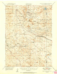
1950 Map of Sherman Mountains
USGS Topo · Published 1950About this map
Lincoln Highway and the Union Pacific railroad trace a historic transport corridor through the high country of the Sherman Mountains in the late 1940s. This survey details a landscape where military training, ranching, and early automotive travel converged. The Fort Francis E. Warren Target and Maneuver Reservation occupies a significant portion of the north, while family-held operations like Mellody Ranch and K P Ranch define the valley floors. Significant landmarks of the transcontinental route are visible, including the massive Ames Monument and the Hermosa Tunnel, alongside now-quiet stations like Tie Siding. The map also highlights the distinctive geological formations of the Medicine Bow National Forest, such as Vedauwoo Glen and the Devils Playground, which have long served as landmarks for travelers crossing the Laramie Range.
Find a feature on this map
88 named features on this map. Tap any name to fly to it.
Don’t see what you’re looking for? This feature index may not catch every label — zoom into the map to look around manually.
Map Details
Editions of this 1950 Sherman Mountains Map
2 editions found

Other maps of this area

1895 · Laramie
USGS Topo · 1:125,000

1902 · Laramie
USGS Topo · 1:125,000

1905 · Sherman
USGS Topo · 1:125,000

1905 · Laramie
USGS Topo · 1:125,000

1906 · Laramie
USGS Topo · 1:125,000

1907 · Livermore
USGS Topo · 1:125,000

1908 · Laramie
USGS Topo · 1:125,000

1909 · Livermore
USGS Topo · 1:125,000

1916 · Home
USGS Topo · 1:125,000

1920 · Home
USGS Topo · 1:125,000