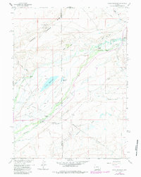
1958 Map of Pierce Reservoir
USGS Topo · Published 1983About this map
The Diamond Dome Gas Field and a network of high-plains ranches define this landscape along the boundary of Carbon and Albany counties. Surveyed in the late 1950s with early 1980s updates, the map reveals an environment deeply shaped by water management and energy extraction. A complex system of irrigation, including the Bosler No 3 Ditch, Big Heart Ditch, and Whites Rock Creek Ditch, cuts across the terrain to support livestock operations like the Double K Ranch and Diamond Ranch. The central Pierce Reservoir and its smaller counterpart, Little Pierce Reservoir, serve as vital landmarks in this arid region. Evidence of local infrastructure is clear through the Double K Ranch Airstrip and numerous oil wells, while the passage of Rock Creek and Coalbank Creek provides the natural drainage that dictated the placement of early settlements and ranch houses.
Find a feature on this map
32 named features on this map. Tap any name to fly to it.
Don’t see what you’re looking for? This feature index may not catch every label — zoom into the map to look around manually.
Map Details
Editions of this 1958 Pierce Reservoir Map
3 editions found
Other maps of this area

1915 · Como Ridge
USGS Topo · 1:48,000

1918 · Como Ridge
USGS Topo · 1:62,500

1954 · Cheyenne
USGS Topo · 1:250,000

1954 · Rawlins
USGS Topo · 1:250,000

1955 · Big Judson
USGS Topo · 1:24,000

1955 · Rock River
USGS Topo · 1:24,000

1955 · Wilcox
USGS Topo · 1:24,000

1958 · Rawlins
USGS Topo · 1:250,000

1958 · Cheyenne
USGS Topo · 1:250,000

1958 · Bengough Hill
USGS Topo · 1:24,000