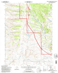
1992 Map of Sherman Mountains West
USGS Topo · Published 1996About this map
Medicine Bow National Forest encompasses the high country of the Sherman Mountains, where the landscape is defined by the legacy of early transcontinental travel. The prominent Ames Monument stands as a massive stone memorial near the southern boundary, overlooking the Old Railroad Grade that once carried the Union Pacific. The topography is etched with numerous drainages including Sawmill Canyon, South Crow Creek, and Harney Creek, while rocky outcrops like Turtle Rock and Point Crawford provide distinctive navigational landmarks.
Find a feature on this map
38 named features on this map. Tap any name to fly to it.
Don’t see what you’re looking for? This feature index may not catch every label — zoom into the map to look around manually.
Map Details
Editions of this 1992 Sherman Mountains West Map
This is the sole edition of this map. No revisions or reprints were ever made.
Other maps of this area

1895 · Laramie
USGS Topo · 1:125,000

1902 · Laramie
USGS Topo · 1:125,000

1905 · Sherman
USGS Topo · 1:125,000

1905 · Laramie
USGS Topo · 1:125,000

1906 · Laramie
USGS Topo · 1:125,000

1908 · Laramie
USGS Topo · 1:125,000

1948 · Sherman Mountains
USGS Topo · 1:62,500

1948 · Ragged Top Mountain
USGS Topo · 1:62,500

1950 · Ragged Top Mountain
USGS Topo · 1:62,500

1950 · Sherman Mountains
USGS Topo · 1:62,500