1990s Maps of Sweetwater County, Wyoming
Explore 16 historic maps of Sweetwater County from the 1990s. These maps offer a rare glimpse into what life looked like during the 1990s — showing old roads, neighborhoods, homes, and landmarks that have changed or disappeared over time.
Whether you're researching your family's past, planning a metal detecting trip, or studying how Sweetwater County's landscape evolved across the 1990s, these high-resolution maps are a powerful tool for exploring the history of this region.
- Focus on a specific era: All maps on this page are from the 1990s, giving you a focused view of this time period.
- See what’s changed: Compare century-old streets, trails, and buildings to today's modern landscape using overlays and satellite layers.
- Research with precision: Use these maps for genealogy, historical research, land use analysis, or educational projects.
- View, download, or print: Maps are fully viewable online in high resolution, and can be downloaded or printed for your own records.
Start exploring Sweetwater County's history through authentic maps from the 1990s. This is your window into the past.
Sweetwater County, WY maps
(16)- 1996 Map of Halfway Hollow East
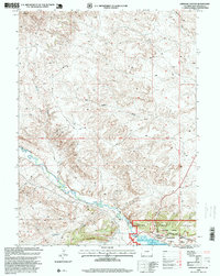
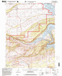
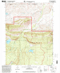
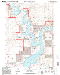 1996 Halfway Hollow East1996 Print · USGSSouthwestern Wyoming's high-desert landscape is captured here in the mid-1990s as the Green River feeds the massive Flaming Gorge Reservoir. Trace the rugged terrain of Halfway Hollow and Currant Creek Ridge through these public lands.
 - 1996 Map of Blacks Fork Bridge, 1999 Print
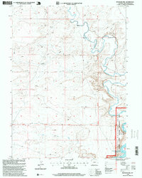
 1996 Blacks Fork Bridge1999 Print · USGSSweetwater County during the late twentieth century reveals a landscape defined by federal land management and water reclamation. Trace the intersection of the Ashley National Forest and Flaming Gorge Reservoir near the Blacks Fork Bridge.
 - 1996 Map of Flaming George, 1999 Print
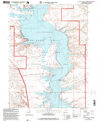
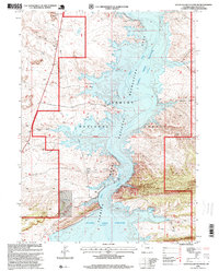
 1996 Flaming George1999 Print · USGSThe high-desert country on the Utah-Wyoming border is captured here in the mid-1990s as the Green River flows into deep canyons. Researchers can locate recreation landmarks like Lucerne Valley Marina alongside older sites such as Trail Creek Ranch and Greendale.
 - 1996 Map of Dutch John, 1999 Print
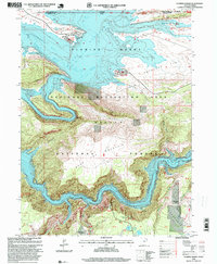
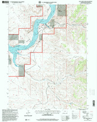
 1996 Dutch John1999 Print · USGSThe Flaming Gorge area in the mid-1990s reflects a landscape defined by massive federal water projects and recreational development. You can trace the local infrastructure from the Flaming Gorge Dam to historic sites like the Sweet Ranch National Historic Site and the Jack Robinson Historic Cabin.
 - 1996 Map of Linwood Canyon, 1999 Print
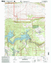
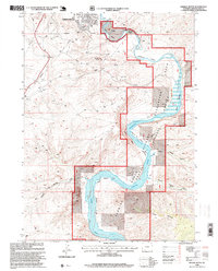
 1996 Linwood Canyon1999 Print · USGSSweetwater County in the mid-1990s shows a landscape of vital water management and recreation at the edge of the Ashley National Forest. Trace the paths of the Peoples Canal and Henrys Fork as they feed the Flaming Gorge Reservoir.
 - 1996 Map of Haystack Buttes North, 1999 Print
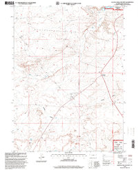
 1996 Haystack Buttes North1999 Print · USGSThe Sweetwater County high desert is shown in the mid-nineties as the Flaming Gorge Reservoir matured into a major recreational hub. Trace the cattle-country roots of the Brinegar Ranch and the boat launches at Buckboard Crossing.
 - 1996 Map of Massacre Hill, 1999 Print
 1996 Massacre Hill1999 Print · USGSThe high desert of Sweetwater County met the expanding waters of the Green River system during the mid-nineties. Researchers can trace the shoreline of Flaming Gorge Reservoir and the prominent heights of Massacre Hill.
 - 1996 Map of Whalen Butte, 1999 Print
 1996 Whalen Butte1999 Print · USGSThe high desert south of Green River comes into focus during the mid-1990s as the river winds through deep canyons and protected forest lands. Researchers can trace the rugged topography of Whalen Butte and the remote river reaches at Whiskey Bend or Slippery Jim Bottom.
 - 1996 Map of Manila, 1999 Print
 1996 Manila1999 Print · USGSNear the Wyoming border in the 1990s, the landscape around Manila reveals a rugged transition from high desert valleys to the deep canyons of the Green River. Researchers can trace recreational development along Flaming Gorge Reservoir or locate the Cem and Summit Springs Guard Station.
 - 1996 Map of Haystack Buttes South, 1999 Print
 1996 Haystack Buttes South1999 Print · USGSSouth of Haystack Buttes in the mid-1990s, the Green River flows through the heart of the Ashley National Forest. Researchers can trace the high-water line of the Flaming Gorge Reservoir and locate landmarks like The Glades and Twin Buttes Draw.
 - 1996 Map of Sage Creek Basin, 2000 Print
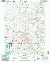
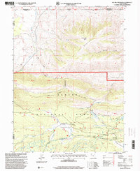
 1996 Sage Creek Basin2000 Print · USGSSweetwater County in the mid-nineties shows the meeting point of high-desert ranching and federal recreation management. Researchers can trace the winding route of the Webster Dugway or find water sources like Greasewood Spring and Sage Creek.
 - 1996 Map of Jessen Butte, 2000 Print
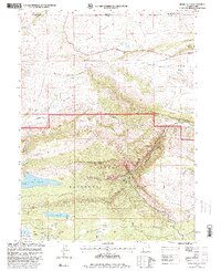 1996 Jessen Butte2000 Print · USGSDaggett County and the Wyoming borderlands are captured here in the late nineties as a landscape of forest management and early military history. You can trace the historic Carter Military Trail or locate remote landmarks like Dowds Grave and Palisades Memorial Park.
 - 1996 Map of Hoop Lake, 2000 Print
 1996 Hoop Lake2000 Print · USGSHigh-altitude borderlands in the Uintas appear here in the mid-nineties as the wilderness and forest boundaries meet. Researchers can trace remote resource infrastructure like the Landing Strip at Gregory Basin and the spillway at Hoop Lake.
 - 1996 Map of Halfway Hollow West, 2000 Print
 1996 Halfway Hollow West2000 Print · USGSSweetwater County's high desert reaches come into focus in the mid-nineties, showing the intersection of recreational lands and industrial infrastructure. Researchers can trace the Flaming Gorge Reservoir shoreline or locate remote landmarks like McKinnon Junction and the Pumping Station.
 - 1996 Map of Devils Playground, 2000 Print
 1996 Devils Playground2000 Print · USGSHigh desert terrain in Sweetwater County comes into focus in the mid-1990s, revealing the complex drainages of the Green River Basin. Researchers can trace the intricate topography of the Devils Playground and locate landmarks like the Pumping Station and Twin Buttes.
 - 1996 Map of Phil Pico Mountain, 2000 Print
 1996 Phil Pico Mountain2000 Print · USGSThe high alpine border between Utah and Wyoming comes into focus in the mid-1990s, showcasing the intersection of historical transit and mountain hydrology. Researchers can trace the Carter Military Trail or locate the Lodgepole Canal Bridge and Hickerson Park.
End of results
Showing maps 1-16 of 16
Top cities of Sweetwater County
- Rock Springs historical maps
- Green River historical maps
- North Rock Springs historical maps
- Clearview Acres historical maps
- James Town historical maps
- Reliance historical maps
See more
Frequently asked questions
- What are the different types of historical maps available for Sweetwater County?
- What is the oldest map of Sweetwater County?
- Where can I purchase historical maps of Sweetwater County for my home or office?
- Where can I download high-res historical maps of Sweetwater County?
- Are there historical topographic maps available for Sweetwater County?
- Is there historical aerial imagery available for Sweetwater County?
- Where are historical maps of Sweetwater County sourced from?