1950s Maps of Sweetwater County, Wyoming
Explore 35 historic maps of Sweetwater County from the 1950s. These maps offer a rare glimpse into what life looked like during the 1950s — showing old roads, neighborhoods, homes, and landmarks that have changed or disappeared over time.
Whether you're researching your family's past, planning a metal detecting trip, or studying how Sweetwater County's landscape evolved across the 1950s, these high-resolution maps are a powerful tool for exploring the history of this region.
- Focus on a specific era: All maps on this page are from the 1950s, giving you a focused view of this time period.
- See what’s changed: Compare century-old streets, trails, and buildings to today's modern landscape using overlays and satellite layers.
- Research with precision: Use these maps for genealogy, historical research, land use analysis, or educational projects.
- View, download, or print: Maps are fully viewable online in high resolution, and can be downloaded or printed for your own records.
Start exploring Sweetwater County's history through authentic maps from the 1950s. This is your window into the past.
Sweetwater County, WY maps
(35)- 1952 Map of Dutch John Mtn, 1954 Print
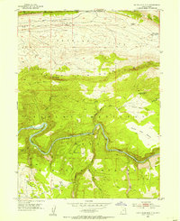 1952 Dutch John Mtn1954 Print · USGSThe Green River backcountry on the Utah-Wyoming border is captured here in the early fifties, just before the Flaming Gorge dam changed the canyon floor forever. Researchers can trace the original river course past Ashley Falls and locate remote sites like the Dutch John Spring Ranger Station and Greendale.2 unique versions available
 - 1952 Map of Flaming Gorge, 1954 Print
 1952 Flaming Gorge1954 Print · USGSThe Green River flows through its natural canyons in the early fifties, just before the landscape was transformed by dam construction. Trace historic land use through Williams Ranch, the Hideout Trail, and river crossings like the Footbridge at Flaming Gorge.2 unique versions available
 - 1954 Map of Salt Lake City, 1964 Print
 1954 Salt Lake City1964 Print · USGSThe Wasatch Front and Uinta Mountains are captured here in the mid-fifties, showing the industrial heart of Utah and its high mountain wilderness. Researchers can locate vanished infrastructure and landmarks like the Geneva Steel Plant, Bingham Canyon Mine, and the Utah State Prison.4 unique versions available
 - 1954 Map of Vernal, 1966 Print
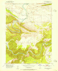
 1954 Vernal1966 Print · USGSThe Green River basin and Uinta Mountains come alive in this mid-century survey of northeastern Utah and northwestern Colorado. Genealogists and researchers can trace the development of remote outposts like Little Bonanza, Artesia, and Dutch John alongside the expanding Flaming Gorge Reservoir.4 unique versions available
 - 1954 Map of Ogden, 1967 Print
 1954 Ogden1967 Print · USGSThe northern Utah corridor and Wyoming borderlands are captured here in the mid-1950s, showing the region's transition from mountain wilderness to settled valleys. Researchers can trace historic institutions like Utah State University or locate vanished points like Church Butte Station and the Trappist Monastery.3 unique versions available
 - 1954 Map of Rawlins, 1968 Print
 1954 Rawlins1968 Print · USGSThe high plains and mountain ranges of southern Wyoming are shown here in the mid-1950s as the Union Pacific railroad and early highways fueled local industry. Genealogists and historians can trace old homesteads and outposts like the Overland Stage Station, the Utah Oil Refining Station, and the Hadsell Winter Headquarters.2 unique versions available
 - 1954 Map of Rock Springs, 1969 Print
 1954 Rock Springs1969 Print · USGSSouthern Wyoming at the peak of the mid-century energy boom is defined by the vital rail corridor and the high desert of the Red Desert Basin. Trace the development of mining towns like Superior and Reliance alongside the Union Pacific RR and historical landmarks like Pilot Butte.2 unique versions available
 - 1955 Map of Preston, 1968 Print
 1955 Preston1968 Print · USGSSoutheast Idaho and western Wyoming are shown in detail during the mid-fifties, from the high Bear River Range to the Green River Basin. Genealogists and collectors can trace the Union Pacific RR through historic towns like Preston, Montpelier, and Afton.3 unique versions available
 - 1955 Map of Lander, 1976 Print
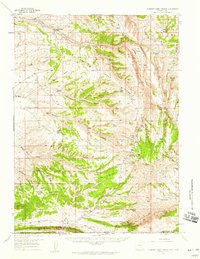
 1955 Lander1976 Print · USGSMid-century central Wyoming is captured here as a landscape of high alpine wilderness and burgeoning energy development. Genealogists and historians can trace the path of the Oregon Trail or locate early industrial sites like the Big Sand Draw Oil and Gas Field and the State Training School.2 unique versions available
 - 1955 Map of Casper, 1977 Print
 1955 Casper1977 Print · USGSCentral Wyoming in the mid-fifties is defined by its massive water projects and an emerging energy economy centered around Casper. Genealogists and historians can trace old ranching outposts like Ervay alongside industrial sites such as the Uranium Mill and Poison Spider Oil Field.
 - 1957 Map of Currant Creek Ranch, 1959 Print
 1957 Currant Creek Ranch1959 Print · USGSThe Wyoming-Utah borderlands are captured here in the late fifties, showing a landscape defined by high ridges and remote ranching outposts. Researchers can trace historic water rights and early trails through Currant Creek Ranch, Minnies Gap, and Sugarloaf Reservoir.2 unique versions available
 - 1957 Map of Mc Kinnon Junction, 1959 Print
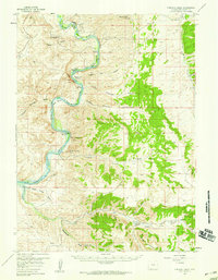
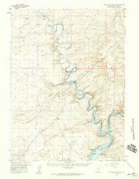 1957 Mc Kinnon Junction1959 Print · USGSSweetwater County ranching and river basins are captured here in the late fifties, showing the complex meanders of the Blacks Fork River. Researchers can trace old family holdings like Bonoma Ranch and Holmes Ranch or locate the site of Massacre Hill.
 - 1957 Map of Firehole Basin, 1959 Print
 1957 Firehole Basin1959 Print · USGSThe Green River corridor in Sweetwater County is shown here in the late fifties, shortly before the landscape was altered by the Flaming Gorge project. Researchers can trace remote homesteads like Kincaid Ranch and unique riverside features including Whiskey Bend and Slippery Jim Bottom.
 - 1958 Map of Rawlins
 1958 Rawlins1958 Print · USGSSouthern Wyoming at the mid-century shows a landscape defined by the Union Pacific Railroad and the high basins of the Continental Divide. Researchers can trace old transportation routes near Fort Fred Steele or explore the mining history around Hanna and Medicine Bow.2 unique versions available
 - 1958 Map of Vernal
 1958 Vernal1958 Print · USGSThe Uinta Basin at the end of the fifties reveals a landscape shaped by massive river systems and burgeoning energy interests. Researchers can trace the layout of Uintah and Ouray Indian Reservation lands and industrial sites like the Gilsonite coking plant and Bonanza.
 - 1958 Map of Casper
 1958 Casper1958 Print · USGSCentral Wyoming in the late fifties is defined by its massive high-desert reservoirs and the burgeoning energy infrastructure around Casper. Genealogists and researchers can trace remote outposts like Bairoil and Love Ranch or locate the Poison Spider Oil Field.2 unique versions available
 - 1958 Map of Lander
 1958 Lander1958 Print · USGSThe high peaks of the Wind River Range meet the Great Divide Basin in the 1950s. Researchers can trace historic migrations past the Oregon Trail Monument or locate early energy infrastructure at the Beaver Creek Gas and Oil Field and the Oregon Trail Oil Field.
 - 1958 Map of Ogden
 1958 Ogden1958 Print · USGSNorthern Utah and southwestern Wyoming are captured here during a period of steady growth and military expansion. You can trace the Union Pacific rail lines and early road networks connecting Ogden and Logan to Bear Lake and Evanston.
 - 1958 Map of Salt Lake City
 1958 Salt Lake City1958 Print · USGSThe Wasatch Front and Uinta Basin are captured during a period of significant post-war growth and industrial development. Researchers can trace the mid-century rail lines of the Bamberger RR and locate sites like the Kiegley Limestone Quarry and Camp Williams Military Reservation.
 - 1958 Map of Rock Springs
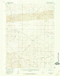
 1958 Rock Springs1958 Print · USGSThe high desert of Sweetwater County comes into focus during the mid-1950s, centered on the rail-and-road corridor through Rock Springs. Genealogists and historians can trace family landholdings and infrastructure at Barnhart Ranch, Little America, and the Union Pacific line.2 unique versions available
 - 1958 Map of Preston
 1958 Preston1958 Print · USGSThe high valleys of the Idaho and Wyoming borderlands are captured here in the late fifties, showcasing a landscape of mountain ranching and phosphate mining. Genealogists and historians can locate early settlements like Chesterfield and Bedford or trace the Union Pacific rail lines serving Cokeville.2 unique versions available
 - 1958 Map of Parting of the Ways, 1960 Print
 1958 Parting of the Ways1960 Print · USGSSouthwestern Wyoming’s high desert was the crossroads of the westward expansion in the late fifties. Trace the legendary Parting of the Ways, the Dry Sandy Stage and Pony Express Sta Site, and the Sublette Cutoff.2 unique versions available
 - 1958 Map of Essex Mountain, 1960 Print
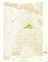
 1958 Essex Mountain1960 Print · USGSThe high desert of Sweetwater County is captured in the late fifties, where the historic Emigrant Trail meets the modern ranching era. Local historians can trace early movement through Packsaddle Canyon and locate remote outposts like the Middle Hay Ranch.2 unique versions available
 - 1958 Map of Boars Tusk, 1960 Print
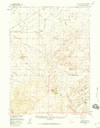
 1958 Boars Tusk1960 Print · USGSSweetwater County ranching and geology are preserved here in the late fifties, showing a remote landscape shaped by the CONTINENTAL DIVIDE. Trace the lineage of high-desert outposts like Lewis Ranch and Houghton Ranch alongside landmarks like Boars Tusk.2 unique versions available
 - 1958 Map of Twelvemile Well, 1960 Print
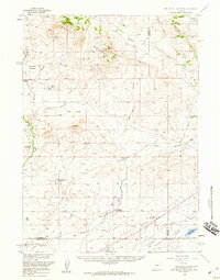
 1958 Twelvemile Well1960 Print · USGSSweetwater County's high desert reaches are captured here in the late fifties, where the Continental Divide cuts through a landscape of dunes and dry washes. Researchers can trace historic movement across the Black Rock Flat via the Rigby Road and locate the remote Twelvemile Well.2 unique versions available
Showing maps 1-25 of 35
Top cities of Sweetwater County
- Rock Springs historical maps
- Green River historical maps
- North Rock Springs historical maps
- Clearview Acres historical maps
- James Town historical maps
- Reliance historical maps
See more
Frequently asked questions
- What are the different types of historical maps available for Sweetwater County?
- What is the oldest map of Sweetwater County?
- Where can I purchase historical maps of Sweetwater County for my home or office?
- Where can I download high-res historical maps of Sweetwater County?
- Are there historical topographic maps available for Sweetwater County?
- Is there historical aerial imagery available for Sweetwater County?
- Where are historical maps of Sweetwater County sourced from?