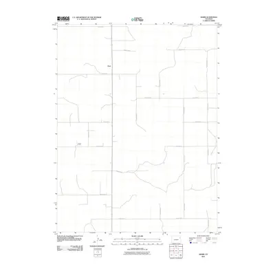
2010 Map of Abarr
USGS Topo · Published 2010About this map
Abarr serves as the central focal point of this high plains landscape in Yuma County, illustrating the sparse settlement patterns typical of the eastern Colorado grasslands. The map reveals a strictly organized grid of agricultural infrastructure, primarily defined by an extensive network of section roads such as County Rd-19 and County Rd G. The presence of the McCoy Ranch west of the main settlement highlights the enduring importance of large-scale ranching operations in this region. This 2010 edition reflects the modern rural landscape before further consolidation of regional homesteads, showing the precise placement of remaining rural dwellings and the essential transport arteries, like County Road K, that link these isolated points across the flat terrain.
Find a feature on this map
16 named features on this map. Tap any name to fly to it.
Don’t see what you’re looking for? This feature index may not catch every label — zoom into the map to look around manually.
Map Details
Editions of this 2010 Abarr Map
This is the sole edition of this map. No revisions or reprints were ever made.
Other maps of this area

1954 · Limon
USGS Topo · 1:250,000

1957 · Limon
USGS Topo · 1:250,000

1958 · Limon
USGS Topo · 1:250,000

1968 · Abarr SE
USGS Topo · 1:24,000

1968 · Joes
USGS Topo · 1:24,000

1968 · Adler Creek
USGS Topo · 1:24,000

1969 · Heartstrong
USGS Topo · 1:24,000

1974 · De Nova SE
USGS Topo · 1:24,000
1974 · Abarr
USGS Topo · 1:24,000
1974 · De Nova NE
USGS Topo · 1:24,000