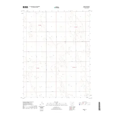
2019 Map of Abarr
USGS Topo · Published 2019About this map
Yuma County’s open High Plains landscape is defined here by a precise grid of rural thoroughfares and section lines. This remote section of eastern Colorado is organized by the Public Land Survey System, as seen in the intersections of townships t2s r48w and t3s r47w. The territory is remarkably sparse, characterized by subtle elevation changes and a network of county roads including Co Rd 21 at the northern edge and Co Rd 13 to the south. A central north-south artery, Co Rd F, bisects the terrain, while east-west routes like Co Rd 16 and Co Rd 19 facilitate travel between scattered homesteads and agricultural plots. The map reveals the structural simplicity of the plains, where the land is carved into regular blocks for farming and ranching, with very few named topographical or man-made features beyond the essential road network.
Find a feature on this map
16 named features on this map. Tap any name to fly to it.
Don’t see what you’re looking for? This feature index may not catch every label — zoom into the map to look around manually.
Map Details
Editions of this 2019 Abarr Map
This is the sole edition of this map. No revisions or reprints were ever made.
Other maps of this area

1954 · Limon
USGS Topo · 1:250,000

1957 · Limon
USGS Topo · 1:250,000

1958 · Limon
USGS Topo · 1:250,000

1968 · Abarr SE
USGS Topo · 1:24,000

1968 · Joes
USGS Topo · 1:24,000

1968 · Adler Creek
USGS Topo · 1:24,000

1969 · Heartstrong
USGS Topo · 1:24,000

1974 · De Nova SE
USGS Topo · 1:24,000
1974 · Abarr
USGS Topo · 1:24,000
1974 · De Nova NE
USGS Topo · 1:24,000