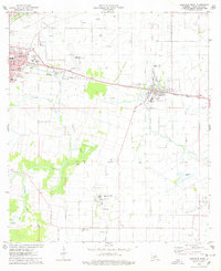
1975 Map of Abbeville East
USGS Topo · Published 1978About this map
Abbeville and its surrounding coastal prairie landscape are captured here during a period of significant industrial activity in the mid-1970s. The region's economy is clearly defined by its natural resources, with the Erath Oil and Gas Field Canal and a large Gas Processing Plant serving as central hubs for energy production. Beyond the oil fields, the area maintains its agricultural roots, evidenced by several Crawfish Farms and the presence of small, traditional settlements like Henry, Boston, and Bancker along the lower reaches of the Vermilion River.
Find a feature on this map
43 named features on this map. Tap any name to fly to it.
Don’t see what you’re looking for? This feature index may not catch every label — zoom into the map to look around manually.
Map Details
Editions of this 1975 Abbeville East Map
This is the sole edition of this map. No revisions or reprints were ever made.
Other maps of this area

1932 · Abbeville SW
USGS Topo · 1:31,680

1932 · Abbeville SE
USGS Topo · 1:31,680

1932 · Abbeville NE
USGS Topo · 1:31,680

1932 · Abbeville NW
USGS Topo · 1:31,680

1937 · Derouen
USGS Topo · 1:62,500

1939 · St. Martinsville
USGS Topo · 1:62,500

1945 · New Orleans
USGS Topo · 1:250,000

1946 · Milton
USGS Topo · 1:31,680

1946 · Leroy
USGS Topo · 1:31,680

1952 · Lake Charles
USGS Topo · 1:250,000