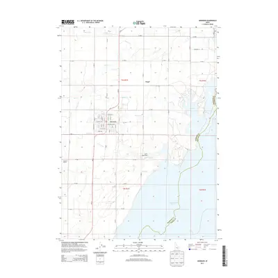
2013 Map of Aberdeen
USGS Topo · Published 2013About this map
Aberdeen serves as the central hub of this agricultural region, situated just west of the expansive American Falls Reservoir. The landscape is defined by an intricate network of irrigation systems essential to the Snake River Plain, including the Highline Canal and the Low Line Canal, which are supported by numerous smaller laterals like Lateral I and Lateral J. These engineering works facilitate farming in the arid Snake River basin, creating a sharp contrast between the irrigated grid and the natural depressions of Big Hole and Little Hole Draw along the reservoir's edge.
Find a feature on this map
42 named features on this map. Tap any name to fly to it.
Don’t see what you’re looking for? This feature index may not catch every label — zoom into the map to look around manually.
Map Details
Editions of this 2013 Aberdeen Map
This is the sole edition of this map. No revisions or reprints were ever made.
Other maps of this area

1934 · American Falls
USGS Topo · 1:62,500

1934 · Michaud
USGS Topo · 1:62,500

1936 · American Falls
USGS Topo · 1:62,500

1937 · Michaud
USGS Topo · 1:62,500

1954 · Pocatello
USGS Topo · 1:250,000

1955 · Springfield
USGS Topo · 1:24,000

1955 · Idaho Falls
USGS Topo · 1:250,000

1958 · Idaho Falls
USGS Topo · 1:250,000

1958 · Pocatello
USGS Topo · 1:250,000
1971 · Schiller
USGS Topo · 1:24,000