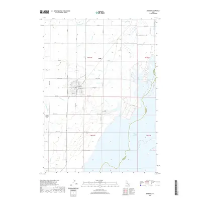
2020 Map of Aberdeen
USGS Topo · Published 2020About this map
Aberdeen serves as the primary hub of this landscape, its grid of streets such as W Central Ave and S Main St situated within an intricate network of irrigation infrastructure. The agricultural character of the region is defined by the Highline Canal and Low Line Canal, which feed a complex series of laterals including Lateral V-1, Lateral J, and Lateral O. These watercourses support the transition from the high desert to the fertile plains surrounding the settlement of Fingal. To the east and south, the geography is dominated by the expansive American Falls Reservoir, with the terrain dipping into Big Hole and the Little Hole Draw. The Aberdeen Municipal Airport provides a modern transport link on the western outskirts, while numerous section roads like Aberdeen Rd and 2700 West Rd grid the countryside, illustrating the systematic division of the Snake River Plain.
Find a feature on this map
65 named features on this map. Tap any name to fly to it.
Don’t see what you’re looking for? This feature index may not catch every label — zoom into the map to look around manually.
Map Details
Editions of this 2020 Aberdeen Map
This is the sole edition of this map. No revisions or reprints were ever made.
Other maps of this area

1934 · American Falls
USGS Topo · 1:62,500

1934 · Michaud
USGS Topo · 1:62,500

1936 · American Falls
USGS Topo · 1:62,500

1937 · Michaud
USGS Topo · 1:62,500

1954 · Pocatello
USGS Topo · 1:250,000

1955 · Springfield
USGS Topo · 1:24,000

1955 · Idaho Falls
USGS Topo · 1:250,000

1958 · Idaho Falls
USGS Topo · 1:250,000

1958 · Pocatello
USGS Topo · 1:250,000
1971 · Schiller
USGS Topo · 1:24,000