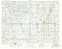
1954 Map of Aberdeen
USGS Topo · Published 1977About this map
The agricultural plains of the James River valley define this mid-1970s revision, where the city of Aberdeen serves as a major hub for the Milwaukee Road and the Chicago and North Western railroads. This survey illustrates the post-war landscape of the Dakota prairie, marked by grain elevators along the rail lines and a network of smaller communities like Eureka, Ipswich, and Groton. The eastern portion of the sheet is dominated by the James River, which feeds the Sand Lake National Wildlife Refuge, a critical sanctuary along the Central Flyway established decades earlier.
Find a feature on this map
125 named features on this map. Tap any name to fly to it.
Don’t see what you’re looking for? This feature index may not catch every label — zoom into the map to look around manually.
Map Details
Editions of this 1954 Aberdeen Map
2 editions found

Other maps of this area

1894 · Conde
USGS Topo · 1:62,500
1894 · Monango
USGS Topo · 1:62,500

1894 · Ellendale
USGS Topo · 1:62,500

1894 · Hecla
USGS Topo · 1:62,500

1894 · Columbia
USGS Topo · 1:62,500

1894 · Savo
USGS Topo · 1:62,500
1894 · Fullerton
USGS Topo · 1:62,500

1894 · Oakes
USGS Topo · 1:62,500

1895 · Byron
USGS Topo · 1:125,000

1895 · Lamoure
USGS Topo · 1:125,000