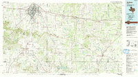
1985 Map of Abilene
USGS Topo · Published 1993About this map
The Callahan Divide cuts across this mid-1980s landscape, separating the drainage of the Leon River from the Pecan Bayou system. The city of Abilene serves as the regional anchor, flanked by the sprawling operations of Dyess Air Force Base and the Abilene Regional Airport. This era shows the established infrastructure of the Missouri Pacific Railroad and Interstate 20 running east-west through towns like Clyde and Baird.
Find a feature on this map
106 named features on this map. Tap any name to fly to it.
Don’t see what you’re looking for? This feature index may not catch every label — zoom into the map to look around manually.
Map Details
Editions of this 1985 Abilene Map
2 editions found
Other maps of this area

1887 · Coleman
USGS Topo · 1:125,000

1889 · Brownwood
USGS Topo · 1:125,000

1889 · Coleman
USGS Topo · 1:125,000

1890 · Breckenridge
USGS Topo · 1:125,000

1890 · Abilene
USGS Topo · 1:125,000

1891 · Hayrick
USGS Topo · 1:125,000

1891 · Anson
USGS Topo · 1:125,000

1892 · Abilene
USGS Topo · 1:125,000

1892 · Ballinger
USGS Topo · 1:125,000

1892 · Albany
USGS Topo · 1:125,000