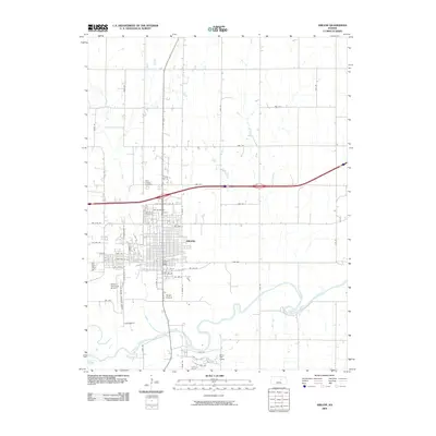
2009 Map of Abilene
USGS Topo · Published 2009About this map
Abilene dominates this landscape, situated just north of the meandering Smoky Hill River. The city's grid is well-established, anchored by the Abilene Post Office and bordered to the south by Wright Airpark. The area's drainage is defined by several waterways that feed into the main river, including Mud Creek which bisects the town, and Turkey Creek to the southeast. On the outskirts, cultural and recreational sites like the Mary-Dell Camp and the Abilene Municipal Airport reflect the town's expansion and infrastructure. For genealogists, the map provides precise locations for both Abilene Cemetery and Saint Joseph Cemetery in the northwestern quadrant of the city. The surrounding rural landscape is divided by a systematic road network, with names like Lark Rd and Game Rd marking the transition into the agricultural plains of Dickinson County.
Find a feature on this map
61 named features on this map. Tap any name to fly to it.
Don’t see what you’re looking for? This feature index may not catch every label — zoom into the map to look around manually.
Map Details
Editions of this 2009 Abilene Map
This is the sole edition of this map. No revisions or reprints were ever made.
Other maps of this area

1889 · Abilene
USGS Topo · 1:125,000

1891 · Clay Center
USGS Topo · 1:125,000

1894 · Abilene
USGS Topo · 1:125,000

1955 · Manhattan
USGS Topo · 1:250,000

1955 · Hutchinson
USGS Topo · 1:250,000

1956 · Manhattan
USGS Topo · 1:250,000

1957 · Manhattan
USGS Topo · 1:250,000

1959 · Hutchinson
USGS Topo · 1:250,000
1963 · Upland
USGS Topo · 1:24,000

1963 · Abilene SW
USGS Topo · 1:24,000