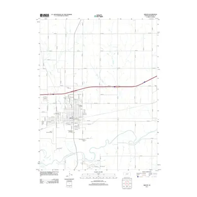
2012 Map of Abilene
USGS Topo · Published 2012About this map
The Smoky Hill River meanders across the southern landscape of this Dickinson County region, defining the drainage patterns for Mud Cr, Turkey Cr, and Holland Cr. The city of Abilene serves as the central hub, organized on a grid that transitions from residential streets like NW 14th ST to the industrial and municipal facilities on its outskirts. The map reveals a community deeply rooted in its local institutions, from the Eisenhower Park Fairgrounds to several significant burial grounds including Abilene Cem and Saint Joseph Cem.
Find a feature on this map
84 named features on this map. Tap any name to fly to it.
Don’t see what you’re looking for? This feature index may not catch every label — zoom into the map to look around manually.
Map Details
Editions of this 2012 Abilene Map
This is the sole edition of this map. No revisions or reprints were ever made.
Other maps of this area

1889 · Abilene
USGS Topo · 1:125,000

1891 · Clay Center
USGS Topo · 1:125,000

1894 · Abilene
USGS Topo · 1:125,000

1955 · Manhattan
USGS Topo · 1:250,000

1955 · Hutchinson
USGS Topo · 1:250,000

1956 · Manhattan
USGS Topo · 1:250,000

1957 · Manhattan
USGS Topo · 1:250,000

1959 · Hutchinson
USGS Topo · 1:250,000
1963 · Upland
USGS Topo · 1:24,000

1963 · Abilene SW
USGS Topo · 1:24,000