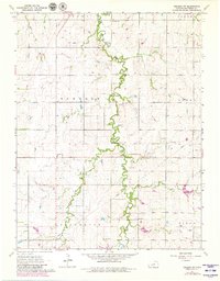
1963 Map of Abilene SW
USGS Topo · Published 1980About this map
Turkey Creek meanders through the heart of this central Kansas landscape, its wooded banks cutting a winding path through the agricultural townships of Newbern, Logan, and Jefferson. The terrain is defined by a dense network of limestone extraction points, with numerous Quarries and small Quarry sites scattered along the creek bluffs, indicating the local importance of stone production. Social and spiritual life in the mid-20th century centered on dispersed rural landmarks such as New Basel Ch and Ebenezer Ch, while the Rural Center Sch served the educational needs of the surrounding farmsteads. Significant for genealogists, the map preserves the locations of several burial grounds, including Farmington Cem and Belle Springs Cem, situated on the upland rises away from the West Branch drainage.
Find a feature on this map
21 named features on this map. Tap any name to fly to it.
Don’t see what you’re looking for? This feature index may not catch every label — zoom into the map to look around manually.
Map Details
Editions of this 1963 Abilene SW Map
2 editions found
Other maps of this area

1889 · Abilene
USGS Topo · 1:125,000

1894 · Abilene
USGS Topo · 1:125,000

1955 · Hutchinson
USGS Topo · 1:250,000

1959 · Hutchinson
USGS Topo · 1:250,000

1963 · Abilene SW
USGS Topo · 1:24,000
1963 · Holland
USGS Topo · 1:24,000
1963 · Solomon
USGS Topo · 1:24,000

1964 · Elmo
USGS Topo · 1:24,000

1964 · Carlton
USGS Topo · 1:24,000
1964 · Chapman
USGS Topo · 1:24,000