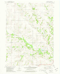
1980 Map of Abingdon
USGS Topo · Published 1981About this map
Abingdon and Batavia anchor the agricultural landscape of this southeast Iowa region along the border of Wapello Co Jefferson Co. This survey from the late 1970s and 1980 illustrates a transition from the rolling drainage basins of Competine Creek and Cedar Creek to the established grid of country roads. The settlement pattern is defined by several rural burial grounds that speak to the area's genealogical history, including Forrest Cem, Dickens Cem, and Walnut Hill Cem. The southern edge of the map is punctuated by the village of Batavia and the Batavia Peoples Ch, where the C M St P & P railroad line runs east-to-west. Other small communities like Bladensburg appear along the secondary routes, providing a detailed look at the township divisions of Competine, Polk, Pleasant, and Locust Grove before modern expansion.
Find a feature on this map
25 named features on this map. Tap any name to fly to it.
Don’t see what you’re looking for? This feature index may not catch every label — zoom into the map to look around manually.
Map Details
Editions of this 1980 Abingdon Map
This is the sole edition of this map. No revisions or reprints were ever made.
Other maps of this area

1954 · Centerville
USGS Topo · 1:250,000

1954 · Des Moines
USGS Topo · 1:250,000

1956 · Des Moines
USGS Topo · 1:250,000

1956 · Farson
USGS Topo · 1:24,000

1956 · Agency
USGS Topo · 1:24,000

1956 · Ottumwa North
USGS Topo · 1:62,500

1956 · Ottumwa South
USGS Topo · 1:62,500

1957 · Des Moines
USGS Topo · 1:250,000

1957 · Centerville
USGS Topo · 1:250,000

1958 · Centerville
USGS Topo · 1:250,000