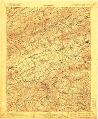
1911 Map of Abingdon
USGS Topo · Published 1921About this map
Abingdon and Marion anchor this survey of the mountainous tri-state border region where Virginia, Tennessee, and North Carolina meet. The landscape is defined by the heavy presence of the Unaka National Forest and the parallel ridges of Walker Mountain and Iron Mountain. The Norfolk and Western Railway serves as a critical corridor through the valley, linking agricultural and industrial hubs like Saltville, known for its geology, and Glade Spring.
Find a feature on this map
157 named features on this map. Tap any name to fly to it.
Don’t see what you’re looking for? This feature index may not catch every label — zoom into the map to look around manually.
Map Details
Editions of this 1911 Abingdon Map
5 editions found

Other maps of this area

1886 · Grundy
USGS Topo · 1:125,000

1887 · Pocahontas
USGS Topo · 1:125,000

1889 · Wytheville
USGS Topo · 1:125,000

1889 · Wilkesboro
USGS Topo · 1:125,000

1890 · Grundy
USGS Topo · 1:125,000

1891 · Tazewell
USGS Topo · 1:125,000

1891 · Pocahontas
USGS Topo · 1:125,000

1891 · Roan Mountain
USGS Topo · 1:125,000

1891 · Abingdon
USGS Topo · 1:125,000

1891 · Wilkesboro
USGS Topo · 1:125,000