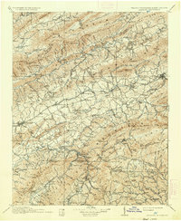
1911 Map of Abingdon
USGS Topo · Published 1936About this map
The Norfolk and Western Railway anchors the industrial and social corridor of this Southwest Virginia landscape, threading through the valleys of the Middle Fork Holston River and connecting established settlements like Glade Spring, Meadowview, and Chilhowie. To the north, the salt-mining center of Saltville and nearby Plasterco reflect the specialized mineral extraction of the era, while the rural interior is dotted with local landmarks like the County Farm and Vestal P.O..
Find a feature on this map
168 named features on this map. Tap any name to fly to it.
Don’t see what you’re looking for? This feature index may not catch every label — zoom into the map to look around manually.
Map Details
Editions of this 1911 Abingdon Map
5 editions found

Other maps of this area

1886 · Grundy
USGS Topo · 1:125,000

1887 · Pocahontas
USGS Topo · 1:125,000

1889 · Wytheville
USGS Topo · 1:125,000

1889 · Wilkesboro
USGS Topo · 1:125,000

1890 · Grundy
USGS Topo · 1:125,000

1891 · Tazewell
USGS Topo · 1:125,000

1891 · Pocahontas
USGS Topo · 1:125,000

1891 · Roan Mountain
USGS Topo · 1:125,000

1891 · Abingdon
USGS Topo · 1:125,000

1891 · Wilkesboro
USGS Topo · 1:125,000