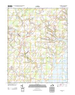
2013 Map of Accomac
USGS Topo · Published 2013About this map
Accomac and the surrounding coastal plains of Virginia's Eastern Shore are defined by a complex network of tidal creeks and fingers of land reaching toward Burtons Bay. The interior landscape is marked by historic crossroads settlements such as Onley, Tasley, and Melfa, which developed along the central spine of the peninsula. These communities are linked by Lankford Hwy, while the coastline is deeply indented by features like Custis Creek and Folly Creek, providing access to the water at sites like Folly Creek Landing. This 2013 survey illustrates the delicate balance between established residential centers and the preserved marshlands of Joynes Neck and Custis Neck. Aviation history and utility infrastructure are also represented through the Johnson Field Airport near Onancock and the Onley Airport further south, showcasing the region's continued importance as a transit corridor between the Chesapeake Bay and the Atlantic.
Find a feature on this map
128 named features on this map. Tap any name to fly to it.
Don’t see what you’re looking for? This feature index may not catch every label — zoom into the map to look around manually.
Map Details
Editions of this 2013 Accomac Map
This is the sole edition of this map. No revisions or reprints were ever made.
Other maps of this area

1903 · Crisfield
USGS Topo · 1:62,500

1920 · Crisfield
USGS Topo · 1:62,500

1931 · Accomac
USGS Topo · 1:48,000

1935 · Accomac
USGS Topo · 1:62,500

1942 · Chesconessex
USGS Topo · 1:31,680

1942 · Mappsville
USGS Topo · 1:24,000

1942 · Parksley
USGS Topo · 1:24,000

1943 · Pungoteague
USGS Topo · 1:31,680

1943 · Parksley
USGS Topo · 1:31,680

1943 · Mappsville
USGS Topo · 1:31,680