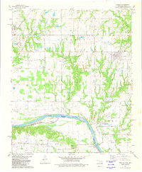
1980 Map of Achille
USGS Topo · Published 1981About this map
The Red River serves as the primary geographical anchor for this borderland study, defining the Oklahoma Texas Boundary as it separates Bryan County from its southern neighbors. The landscape is characterized by a network of creek drainages including Sandy Creek, Eastman Creek, and Rock Creek, which cut through the terrain toward the river basin. Cultural landmarks are scattered throughout the agricultural and wooded sections, with small spiritual and commemorative sites like Murray Hill Ch and Colbert Cem providing specific points of interest for local history.
Find a feature on this map
28 named features on this map. Tap any name to fly to it.
Don’t see what you’re looking for? This feature index may not catch every label — zoom into the map to look around manually.
Map Details
Editions of this 1980 Achille Map
This is the sole edition of this map. No revisions or reprints were ever made.
Other maps of this area

1901 · Denison
USGS Topo · 1:125,000

1954 · Sherman
USGS Topo · 1:250,000

1957 · Denison Dam
USGS Topo · 1:24,000

1958 · Durant
USGS Topo · 1:62,500

1958 · Whitesright
USGS Topo · 1:62,500

1958 · Denison Dam
USGS Topo · 1:62,500

1958 · Sherman
USGS Topo · 1:250,000

1958 · Sherman
USGS Topo · 1:62,500

1958 · Sherman
USGS Topo · 1:24,000
1980 · Durant South
USGS Topo · 1:24,000