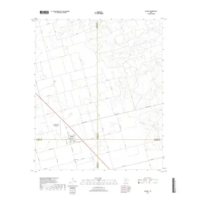
2019 Map of Ackerly
USGS Topo · Published 2019About this map
Ackerly sits at the unique junction of four West Texas counties — Dawson, Borden, Martin, and Howard — serving as a remote crossroads for local agriculture and cattle ranching. This high-plains landscape is defined by the ephemeral drainages of Wolf Cr, Glen Cr, and Rattlesnake Cr, which carve subtle relief into the flat terrain. The map records the local grid of farm roads and ranch routes, such as Ranch Rd 1584 and FM 2212, that connect the isolated homesteads and pastures characteristic of the Llano Estacado. Evidence of the region’s specialized economy is clear with the presence of the Coleman Cattle Company Number 1 Airport, while local genealogy is grounded at the Fairhaven Cem south of the town center. The geometry of the county lines meeting precisely at the southern edge of the settlement provides a distinct boundary perspective for researchers of local land history.
Find a feature on this map
55 named features on this map. Tap any name to fly to it.
Don’t see what you’re looking for? This feature index may not catch every label — zoom into the map to look around manually.
Map Details
Editions of this 2019 Ackerly Map
This is the sole edition of this map. No revisions or reprints were ever made.
Other maps of this area

1954 · Big Spring
USGS Topo · 1:250,000

1958 · Big Spring
USGS Topo · 1:250,000

1966 · Knott
USGS Topo · 1:24,000

1966 · Merrick
USGS Topo · 1:24,000

1966 · Knott NE
USGS Topo · 1:24,000

1970 · Vealmoor
USGS Topo · 1:24,000

1970 · Ackerly
USGS Topo · 1:24,000

1970 · Key
USGS Topo · 1:24,000

1970 · Sand Creek
USGS Topo · 1:24,000
1970 · Sparenberg
USGS Topo · 1:24,000