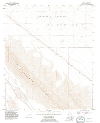
1992 Map of Acolita
USGS Topo · Published 1995About this map
The settlement of Acolita serves as a small anchor in this desert landscape, situated along the diagonal path of the Niland - Glamis Road. The geography is defined by a series of engineered barriers and expansive natural features, including a prominent Dike system and the massive shifting sands of the Algodones Dunes. These dunes dominate the southern portion of the map, contrasting with the structured irrigation of the Coachella Canal and the adjacent Levee that skirts the East Mesa.
Find a feature on this map
11 named features on this map. Tap any name to fly to it.
Don’t see what you’re looking for? This feature index may not catch every label — zoom into the map to look around manually.
Map Details
Editions of this 1992 Acolita Map
This is the sole edition of this map. No revisions or reprints were ever made.
Other maps of this area

1907 · Holtville
USGS Topo · 1:125,000

1940 · Iris
USGS Topo · 1:62,500

1940 · Alamorio
USGS Topo · 1:62,500

1942 · El Centro
USGS Topo · 1:250,000

1945 · Alamorio
USGS Topo · 1:62,500

1945 · Iris
USGS Topo · 1:62,500

1953 · Acolita
USGS Topo · 1:24,000

1953 · Acolita
USGS Topo · 1:62,500

1954 · El Centro
USGS Topo · 1:250,000

1954 · Salton Sea
USGS Topo · 1:250,000