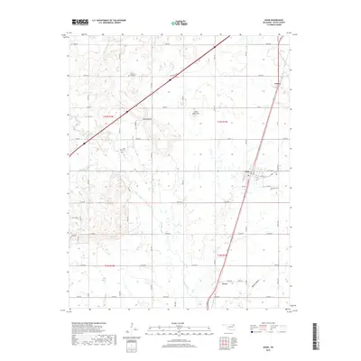
2019 Map of Adair
USGS Topo · Published 2019About this map
Adair serves as the central hub for this corner of Mayes County, where the grid of rural roads meets the primary north-south transportation corridor. The landscape is defined by the winding course of Pryor Creek and its tributaries, including Bitter Cr and Osage Cr, which cut through the undulating terrain of the Cherokee Nation. Local history is etched into the land at landmarks like Jesse James Hill and the topographic break known as Whiskey Gap. For genealogists, the map preserves the locations of several community burial grounds, from the centrally located Adair Cem to the outlying Hope Cem near Pleasant and Rider Cem to the west. Smaller settlements such as Patton in the northeast and Green in the south indicate the persistent rural community structure of the late 2010s, connected by a network of established section-line roads like Strang RD and e0380 RD.
Find a feature on this map
55 named features on this map. Tap any name to fly to it.
Don’t see what you’re looking for? This feature index may not catch every label — zoom into the map to look around manually.
Map Details
Editions of this 2019 Adair Map
This is the sole edition of this map. No revisions or reprints were ever made.
Other maps of this area

1896 · Pryor
USGS Topo · 1:125,000

1901 · Vinita
USGS Topo · 1:125,000

1901 · Pryor
USGS Topo · 1:125,000

1913 · Vinita
USGS Topo · 1:125,000

1954 · Tulsa
USGS Topo · 1:250,000

1958 · Tulsa
USGS Topo · 1:250,000

1963 · Tulsa
USGS Topo · 1:250,000

1969 · Adair
USGS Topo · 1:24,000
1970 · Bushyhead
USGS Topo · 1:24,000

1970 · Chelsea
USGS Topo · 1:24,000