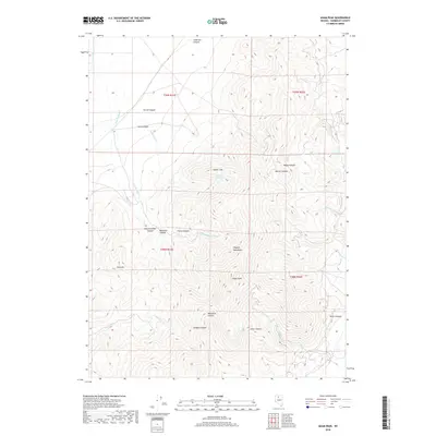
2018 Map of Adam Peak
USGS Topo · Published 2018About this map
Adam Peak stands as the central topographic anchor in this portion of the Osgood Mountains, where the high desert landscape is deeply incised by a series of radial canyons. The drainage pattern here is defined by seasonal watercourses like Eden Cr and its eastern fork, which flow through Cave Canyon and Farrel Canyon toward the valley floors. High-elevation points like Soldier Cap and the Dry Hills overlook a network of ephemeral streams, including Julian Cr and Summer Camp Cr.
Find a feature on this map
29 named features on this map. Tap any name to fly to it.
Don’t see what you’re looking for? This feature index may not catch every label — zoom into the map to look around manually.
Map Details
Editions of this 2018 Adam Peak Map
This is the sole edition of this map. No revisions or reprints were ever made.
Other maps of this area

1882 · Paradise
USGS Topo · 1:250,000

1893 · Paradise
USGS Topo · 1:250,000

1945 · Osgood Mountains
USGS Topo · 1:62,500

1945 · Hot Springs
USGS Topo · 1:62,500

1947 · Osgood Mountains
USGS Topo · 1:62,500

1947 · Hot Springs Peak
USGS Topo · 1:62,500

1955 · McDermitt
USGS Topo · 1:250,000

1959 · McDermitt
USGS Topo · 1:250,000

1980 · Dry Hills South
USGS Topo · 1:24,000
1980 · Red House Flat East
USGS Topo · 1:24,000