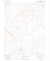
1980 Map of Red House Flat East
USGS Topo · Published 1980About this map
Red House Flat dominates this desert basin in Humboldt County, defined by its expansive alkali flats and a network of seasonal watercourses. The landscape is marked by the presence of isolated outposts such as Allex Place and Dudley Place, which suggest the sparse, ranching-oriented settlement pattern of northern Nevada in the late 20th century. Water management is a primary theme of the sheet, evidenced by numerous named groundwater sources including the Phillip Hammond Well, Carl Hammond Well, and the aptly named Prosperous Pond.
Find a feature on this map
22 named features on this map. Tap any name to fly to it.
Don’t see what you’re looking for? This feature index may not catch every label — zoom into the map to look around manually.
Map Details
Editions of this 1980 Red House Flat East Map
This is the sole edition of this map. No revisions or reprints were ever made.
Other maps of this area

1882 · Paradise
USGS Topo · 1:250,000

1893 · Paradise
USGS Topo · 1:250,000

1932 · Sonoma Range
USGS Topo · 1:250,000

1939 · Sonoma Range
USGS Topo · 1:250,000

1945 · Osgood Mountains
USGS Topo · 1:62,500

1947 · Osgood Mountains
USGS Topo · 1:62,500

1955 · McDermitt
USGS Topo · 1:250,000

1955 · Winnemucca
USGS Topo · 1:250,000

1958 · Winnemucca
USGS Topo · 1:250,000

1959 · McDermitt
USGS Topo · 1:250,000