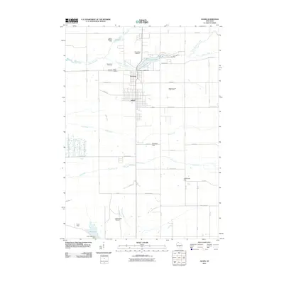
2010 Map of Adams
USGS Topo · Published 2010About this map
Friendship Mound and Rattlesnake Mound rise above the central Wisconsin landscape, defining the topography surrounding the adjacent communities of Adams and Friendship. This 2010 survey details a region where natural sandstone features such as Lighthouse Rock, Houghton Rock, and Lone Rock punctuate the level terrain between numerous drainages. The local economy and recreation center on Friendship Lake, managed by the Friendship 2WP745 Dam, and the nearby Mound View Golf Course. Genealogists will find the locations of Mount Repose Cemetery and Saint Leos Cemetery clearly marked on the northern edge of the settlements. The map also records the hydrological network of the area, including Little Roche a Cri Creek, Duck Creek, and Klein Creek, which crisscross the grid of county highways and local avenues such as Czech Ave.
Find a feature on this map
58 named features on this map. Tap any name to fly to it.
Don’t see what you’re looking for? This feature index may not catch every label — zoom into the map to look around manually.
Map Details
Editions of this 2010 Adams Map
This is the sole edition of this map. No revisions or reprints were ever made.
Other maps of this area

1955 · Green Bay
USGS Topo · 1:250,000

1957 · Madison
USGS Topo · 1:250,000

1958 · Arkdale
USGS Topo · 1:48,000

1958 · Coloma
USGS Topo · 1:48,000

1960 · Madison
USGS Topo · 1:250,000

1961 · Oxford
USGS Topo · 1:62,500

1961 · Adams
USGS Topo · 1:62,500

1967 · Roche A Cri
USGS Topo · 1:24,000
1967 · Arkdale
USGS Topo · 1:24,000

1968 · Coloma SW
USGS Topo · 1:24,000