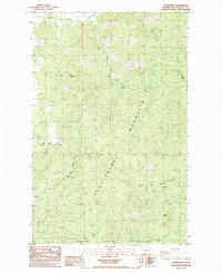
1985 Map of Adams Mtn
USGS Topo · Published 1985About this map
Mining operations dominate this mid-1980s terrain in Stevens County, where the southern slopes of Huckleberry Mountain meet the northern edge of the Spokane Indian Reservation. This map documents a high-altitude industrial landscape defined by numerous mineral extraction sites, including the Cleveland Mine in the northeast and the Germania Mine in the southwest. Between these points, smaller operations like the Turk Mine, Togo Mine, and Deer Trail Mine follow the rugged drainages of Cedar Canyon and Alder Creek. The settlement of Turk sits as a lonely outlier near the western boundary. Hydrologically, the area divides between the Hunter Creek system flowing north and the South Fork Chamokane Creek heading south toward the reservation, illustrating the complex watershed that governed early access to these remote mountain claims.
Find a feature on this map
22 named features on this map. Tap any name to fly to it.
Don’t see what you’re looking for? This feature index may not catch every label — zoom into the map to look around manually.
Map Details
Editions of this 1985 Adams Mtn Map
2 editions found
Other maps of this area

1927 · Chewelah
USGS Topo · 1:125,000

1930 · Chewelah
USGS Topo · 1:125,000

1944 · Wellpinit
USGS Topo · 1:62,500

1948 · Hunters
USGS Topo · 1:62,500

1948 · Turtle Lake
USGS Topo · 1:62,500

1950 · Turtle Lake
USGS Topo · 1:62,500

1950 · Hunters
USGS Topo · 1:62,500

1953 · Wellpinit
USGS Topo · 1:62,500

1953 · Ritzville
USGS Topo · 1:250,000

1954 · Okanogan
USGS Topo · 1:250,000