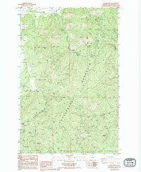
1985 Map of Adams Mtn
USGS Topo · Published 1994About this map
Mining operations and the high ridges of the Huckleberry Range define this mid-1980s landscape in Stevens County. The area is characterized by an extensive history of resource extraction, with significant sites including the Cleveland Mine in the north and the Germania Mine to the south. The small settlement of Turk sits at the junction of Alder Creek and Hunter Creek, serving as a focal point for the surrounding terrain. To the south, the boundary of the Spokane Indian Reservation borders a landscape drained by the South Fork Chamokane Creek. The topography is dominated by massive peaks like Huckleberry Mountain and Adams Mtn, while the network of drainage basins such as Cedar Canyon and Owl Creek illustrates the complex watershed that directed early movement and industry through these mountains.
Find a feature on this map
21 named features on this map. Tap any name to fly to it.
Don’t see what you’re looking for? This feature index may not catch every label — zoom into the map to look around manually.
Map Details
Editions of this 1985 Adams Mtn Map
2 editions found
Other maps of this area

1927 · Chewelah
USGS Topo · 1:125,000

1930 · Chewelah
USGS Topo · 1:125,000

1944 · Wellpinit
USGS Topo · 1:62,500

1948 · Hunters
USGS Topo · 1:62,500

1948 · Turtle Lake
USGS Topo · 1:62,500

1950 · Turtle Lake
USGS Topo · 1:62,500

1950 · Hunters
USGS Topo · 1:62,500

1953 · Wellpinit
USGS Topo · 1:62,500

1953 · Ritzville
USGS Topo · 1:250,000

1954 · Okanogan
USGS Topo · 1:250,000