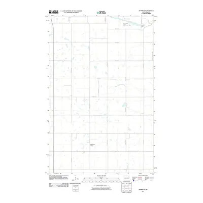
2011 Map of Adams SE
USGS Topo · Published 2011About this map
ZCBJ Narodni Hrbitov Cemetery serves as a significant cultural landmark in this rural landscape of Walsh County, its name reflecting the heritage of the Czech fraternal organization, Zapadni Ceska Bratrska Jednota. The surrounding terrain is defined by an intricate network of section-line roads and the winding path of the North Branch Forest River in the northeast. Water management is a primary feature of the local geography, evidenced by several small-scale impoundments including Dougherty Dam, Bylin Dam, and the North Branch Forest River Number 1 Dam. This area remains largely defined by its agricultural grid, with major thoroughfares like County Rd 15 and County Rd 16 providing the primary connectivity between the dispersed farmsteads and prairie potholes that dot the township.
Find a feature on this map
22 named features on this map. Tap any name to fly to it.
Don’t see what you’re looking for? This feature index may not catch every label — zoom into the map to look around manually.
Map Details
Editions of this 2011 Adams SE Map
This is the sole edition of this map. No revisions or reprints were ever made.
Other maps of this area

1952 · Thief River Falls
USGS Topo · 1:250,000

1953 · Devils Lake
USGS Topo · 1:250,000

1956 · Thief River Falls
USGS Topo · 1:250,000

1956 · Devils Lake
USGS Topo · 1:250,000

1957 · Thief River Falls
USGS Topo · 1:250,000

1967 · Thief River Falls
USGS Topo · 1:250,000

1971 · Whitman
USGS Topo · 1:24,000
1971 · Dahlen
USGS Topo · 1:24,000

1971 · Pelto
USGS Topo · 1:24,000

1972 · Adams
USGS Topo · 1:24,000