
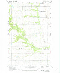
1972 Map of Adams
USGS Topo · Published 1975About this map
Adams serves as the central hub of this northern Red River Valley landscape, situated where the Soo Line railroad bisects the prairie. The town's grid is surrounded by essential local landmarks including a Townhall and several burial grounds such as Trinity Cem, West Adams Cem, and East Adams Cem. Outside the immediate settlement, the topography is defined by the meandering South Branch Forest River, which drains the glacial till plain. Small-scale aviation and industrial activity are evident through the Skyrud Landing Strip, a Radio Tower, and a Gravel Pit. The map also highlights conservation efforts with the inclusion of the National Waterfowl Production Area, reflecting the region's importance as a migratory habitat.
Find a feature on this map
18 named features on this map. Tap any name to fly to it.
Don’t see what you’re looking for? This feature index may not catch every label — zoom into the map to look around manually.
Map Details
Editions of this 1972 Adams Map
This is the sole edition of this map. No revisions or reprints were ever made.
Other maps of this area

1952 · Thief River Falls
USGS Topo · 1:250,000

1953 · Devils Lake
USGS Topo · 1:250,000

1956 · Thief River Falls
USGS Topo · 1:250,000

1956 · Devils Lake
USGS Topo · 1:250,000

1957 · Thief River Falls
USGS Topo · 1:250,000

1967 · Thief River Falls
USGS Topo · 1:250,000

1972 · Osnabrock SW
USGS Topo · 1:24,000
1972 · Edinburg NW
USGS Topo · 1:24,000

1972 · Adams SW
USGS Topo · 1:24,000

1972 · Fairdale
USGS Topo · 1:24,000