
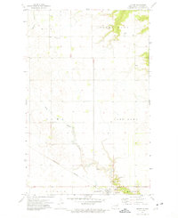
1972 Map of Osnabrock SW
USGS Topo · Published 1975About this map
Osnabrock and Osford townships define this portion of northeastern North Dakota, where the South Branch Park River carves a winding path through the northern landscape. This 1972 survey records the rural fabric of the region, anchored by community structures like the Townhall and the Soper Ch. The map illustrates a high density of local heritage sites, including the Highland Cem and Soper Cem, which provide valuable location data for genealogists and local historians tracking early settlement patterns across Cavalier and Walsh counties.
Find a feature on this map
15 named features on this map. Tap any name to fly to it.
Don’t see what you’re looking for? This feature index may not catch every label — zoom into the map to look around manually.
Map Details
Editions of this 1972 Osnabrock SW Map
This is the sole edition of this map. No revisions or reprints were ever made.
Other maps of this area

1953 · Devils Lake
USGS Topo · 1:250,000

1956 · Devils Lake
USGS Topo · 1:250,000

1972 · Osnabrock
USGS Topo · 1:24,000

1972 · Nekoma
USGS Topo · 1:24,000

1972 · Easby
USGS Topo · 1:24,000
1972 · Milton
USGS Topo · 1:24,000

1972 · Adams
USGS Topo · 1:24,000

1972 · Fairdale
USGS Topo · 1:24,000

1972 · Edmore NE
USGS Topo · 1:24,000
1972 · Waterloo Lake
USGS Topo · 1:24,000