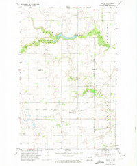
1971 Map of Dahlen
USGS Topo · Published 1974About this map
Dahlen serves as the central hub of this North Dakota landscape, situated at the crossroads of several township boundaries including Dahlen, Cleveland, and Elk Mount. The area is defined by the winding paths of the Middle Branch Forest River and the South Branch Forest River, which carve through the prairie terrain. A notable engineering feature is the Matejcek Dam, which creates a significant reservoir along the Middle Branch.
Find a feature on this map
18 named features on this map. Tap any name to fly to it.
Don’t see what you’re looking for? This feature index may not catch every label — zoom into the map to look around manually.
Map Details
Editions of this 1971 Dahlen Map
This is the sole edition of this map. No revisions or reprints were ever made.
Other maps of this area

1952 · Thief River Falls
USGS Topo · 1:250,000

1953 · Devils Lake
USGS Topo · 1:250,000

1956 · Thief River Falls
USGS Topo · 1:250,000

1956 · Devils Lake
USGS Topo · 1:250,000

1957 · Thief River Falls
USGS Topo · 1:250,000

1963 · Pleasant Valley
USGS Topo · 1:24,000

1963 · Fordville SE
USGS Topo · 1:24,000

1963 · Fordville
USGS Topo · 1:24,000

1967 · Thief River Falls
USGS Topo · 1:250,000
1971 · Michigan East
USGS Topo · 1:24,000