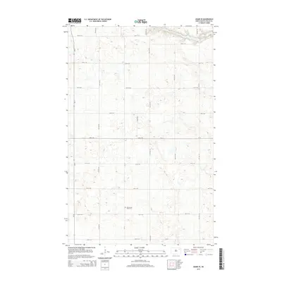
2014 Map of Adams SE
USGS Topo · Published 2014About this map
ZCBJ Narodni Hrbitov Cem serves as a significant cultural landmark in this rural section of Walsh County, reflecting the Czech heritage of the early settlers in North Dakota. The landscape is primarily defined by a high-density grid of local section roads, including Nd-35, Cr-16, and Cr-15, which organize the agricultural terrain. In the northern reaches of the quadrangle, the topography shifts as the N Br Forest River carves through the plains. The river's drainage patterns provide a distinct contrast to the otherwise uniform section lines, such as 66th St NE and 122nd Ave NE, illustrating how natural watercourses influenced the layout of land regardless of the geometric township and range system. This 2014 survey documents the enduring spatial organization of the region's farming economy.
Find a feature on this map
22 named features on this map. Tap any name to fly to it.
Don’t see what you’re looking for? This feature index may not catch every label — zoom into the map to look around manually.
Map Details
Editions of this 2014 Adams SE Map
This is the sole edition of this map. No revisions or reprints were ever made.
Other maps of this area

1952 · Thief River Falls
USGS Topo · 1:250,000

1953 · Devils Lake
USGS Topo · 1:250,000

1956 · Thief River Falls
USGS Topo · 1:250,000

1956 · Devils Lake
USGS Topo · 1:250,000

1957 · Thief River Falls
USGS Topo · 1:250,000

1967 · Thief River Falls
USGS Topo · 1:250,000

1971 · Whitman
USGS Topo · 1:24,000
1971 · Dahlen
USGS Topo · 1:24,000

1971 · Pelto
USGS Topo · 1:24,000

1972 · Adams
USGS Topo · 1:24,000