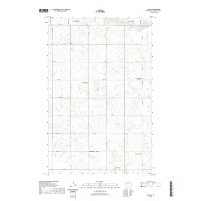
2020 Map of Adams SE
USGS Topo · Published 2020About this map
Sarepta Lutheran Cem stands in the northern reaches of this Walsh County landscape, anchoring a rural township grid characterized by small seasonal wetlands and prairie depressions. This 2020 survey reveals a quiet agricultural interior defined by the North Branch Forest River as it meanders through the northeastern corner. The area’s heritage is preserved through dispersed sites like the Narodni Cem and Bechyne Cem, which speak to the immigrant communities that settled the plains of North Dakota. Modern transit follows established section lines, including Prairie Trl and Co Hwy 16, while the landscape remains primarily dedicated to open field cultivation and local water management.
Find a feature on this map
29 named features on this map. Tap any name to fly to it.
Don’t see what you’re looking for? This feature index may not catch every label — zoom into the map to look around manually.
Map Details
Editions of this 2020 Adams SE Map
This is the sole edition of this map. No revisions or reprints were ever made.
Other maps of this area

1952 · Thief River Falls
USGS Topo · 1:250,000

1953 · Devils Lake
USGS Topo · 1:250,000

1956 · Thief River Falls
USGS Topo · 1:250,000

1956 · Devils Lake
USGS Topo · 1:250,000

1957 · Thief River Falls
USGS Topo · 1:250,000

1967 · Thief River Falls
USGS Topo · 1:250,000

1971 · Whitman
USGS Topo · 1:24,000
1971 · Dahlen
USGS Topo · 1:24,000

1971 · Pelto
USGS Topo · 1:24,000

1972 · Adams
USGS Topo · 1:24,000