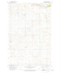
1972 Map of Adams SE
USGS Topo · Published 1975About this map
The North Branch Forest River winds through the northeast corner of this Walsh County landscape, defining the northern limit of a region organized into the townships of Adams, Vesta, Latona, Norton, Perth, and Cleveland. This rural interior of North Dakota is characterized by a high density of small prairie potholes and wetlands, much of which is preserved within the National Waterfowl Production Area. Local social and spiritual life is anchored by dispersed landmarks including the Sarepta Ch, Bechyna Ch, and the Kosobud Community Hall. For genealogists, the map identifies the Narodni Cem and another smaller Cem near the northern boundary. The presence of several Gravel Pit sites and a local Townhall reflects the township-based civic and resource-gathering structure typical of this agricultural era.
Find a feature on this map
16 named features on this map. Tap any name to fly to it.
Don’t see what you’re looking for? This feature index may not catch every label — zoom into the map to look around manually.
Map Details
Editions of this 1972 Adams SE Map
This is the sole edition of this map. No revisions or reprints were ever made.
Other maps of this area

1952 · Thief River Falls
USGS Topo · 1:250,000

1953 · Devils Lake
USGS Topo · 1:250,000

1956 · Thief River Falls
USGS Topo · 1:250,000

1956 · Devils Lake
USGS Topo · 1:250,000

1957 · Thief River Falls
USGS Topo · 1:250,000

1967 · Thief River Falls
USGS Topo · 1:250,000

1971 · Whitman
USGS Topo · 1:24,000
1971 · Dahlen
USGS Topo · 1:24,000

1971 · Pelto
USGS Topo · 1:24,000

1972 · Adams
USGS Topo · 1:24,000