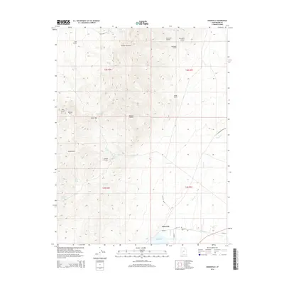
2014 Map of Adamsville
USGS Topo · Published 2014About this map
Adamsville serves as the focal point of this western Utah survey, situated at the confluence of the Beaver River and the northern reaches of the Minersville Reservoir. The landscape transition is stark, moving from the irrigated flats served by the Furnace Ditch and the Adamsville Bench into the steep, spring-fed elevations of the Mineral Mountains. Genealogists will find the Adamsville Cem clearly marked just east of the main settlement along E Main St. Higher elevations to the west and north are defined by numerous named features such as Harkley Mtn, Soldier Pass, and Granite Peak Reservoir. The distribution of water sources like Rock Corral Spring and Dripping Spring highlights the historical importance of localized hydrology for ranching and travel in this arid terrain, while the rugged drainage patterns of Lincoln Gulch and Granite Canyon reveal the complex topography surrounding the community.
Find a feature on this map
39 named features on this map. Tap any name to fly to it.
Don’t see what you’re looking for? This feature index may not catch every label — zoom into the map to look around manually.
Map Details
Editions of this 2014 Adamsville Map
This is the sole edition of this map. No revisions or reprints were ever made.
Other maps of this area

1885 · Beaver
USGS Topo · 1:250,000

1953 · Minersville
USGS Topo · 1:24,000

1953 · Cave Canyon
USGS Topo · 1:24,000

1953 · Richfield
USGS Topo · 1:250,000

1958 · Richfield
USGS Topo · 1:250,000

1958 · Minersville
USGS Topo · 1:62,500

1958 · Beaver
USGS Topo · 1:62,500

1958 · Adamsville
USGS Topo · 1:62,500

1958 · Ranch Canyon
USGS Topo · 1:24,000
1971 · Greenville Bench
USGS Topo · 1:24,000