
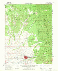
1958 Map of Beaver
USGS Topo · Published 1960About this map
Beaver serves as the focal point of this late-1950s survey, showing the town's layout during a period of steady post-war stability. The map documents the local educational infrastructure with the Beaver High Sch and Belknap Sch clearly marked, alongside the Mtn View Cemetery to the north. To the west, the smaller settlement of Greenville sits near Little Bald Hill, while Manderfield occupies the valley floor to the north along U S 91.
Find a feature on this map
61 named features on this map. Tap any name to fly to it.
Don’t see what you’re looking for? This feature index may not catch every label — zoom into the map to look around manually.
Map Details
Editions of this 1958 Beaver Map
2 editions found
Other maps of this area

1885 · Beaver
USGS Topo · 1:250,000

1932 · Sevier
USGS Topo · 1:62,500

1935 · Sevier
USGS Topo · 1:62,500

1937 · Delano Peak
USGS Topo · 1:48,000

1943 · Delano Peak
USGS Topo · 1:62,500

1953 · Richfield
USGS Topo · 1:250,000

1954 · Beaver SE
USGS Topo · 1:24,000

1954 · Beaver NE
USGS Topo · 1:24,000

1958 · Richfield
USGS Topo · 1:250,000

1958 · Minersville
USGS Topo · 1:62,500