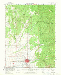
1958 Map of Beaver
USGS Topo · Published 1971About this map
The Beaver community sits at the heart of this mid-century landscape, serving as a hub for the agricultural and mining operations of the surrounding Fishlake National Forest. A sophisticated network of irrigation canals, including Mammoth Ditch, Harris Ditch, and Willis Ditch, branches out from the Beaver River to support the local Fields. Educational and civic life is centered at the Belknap Sch and Beaver High Sch, while the nearby Mtn View Cemetery provides a primary point for genealogical research.
Find a feature on this map
123 named features on this map. Tap any name to fly to it.
Don’t see what you’re looking for? This feature index may not catch every label — zoom into the map to look around manually.
Map Details
Editions of this 1958 Beaver Map
2 editions found

Other maps of this area

1885 · Beaver
USGS Topo · 1:250,000

1932 · Sevier
USGS Topo · 1:62,500

1935 · Sevier
USGS Topo · 1:62,500

1937 · Delano Peak
USGS Topo · 1:48,000

1943 · Delano Peak
USGS Topo · 1:62,500

1953 · Richfield
USGS Topo · 1:250,000

1954 · Beaver SE
USGS Topo · 1:24,000

1954 · Beaver NE
USGS Topo · 1:24,000

1958 · Richfield
USGS Topo · 1:250,000

1958 · Minersville
USGS Topo · 1:62,500