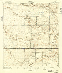
1918 Map of Addicks
USGS Topo · Published 1949About this map
Buffalo Bayou and its numerous tributaries, including South Mayde Creek and Langham Creek, dominate this prairie landscape west of Houston during the early twentieth century. The Missouri Kansas and Texas railroad corridor serves as the primary East-West axis for the small rail stops of Delhi, Barker, and Addicks. This era represents a transition from scattered rural holdings like the Gertie Rice Farm to more organized community hubs, evidenced by the cluster of social and educational landmarks. Family and community history is anchored here by institutions such as the German Methodist Church and a series of rural schoolhouses, including the Grisbee School and McGee School. Infrastructure of the day is marked by Bakers Dam and the emerging road network defined by the Katy Cross Road and Clodine Road.
Find a feature on this map
20 named features on this map. Tap any name to fly to it.
Don’t see what you’re looking for? This feature index may not catch every label — zoom into the map to look around manually.
Map Details
Editions of this 1918 Addicks Map
2 editions found
Other maps of this area

1915 · Alief
USGS Topo · 1:24,000

1915 · Cypress
USGS Topo · 1:24,000

1915 · Katy
USGS Topo · 1:24,000

1915 · Addicks
USGS Topo · 1:24,000

1915 · Hillendahl
USGS Topo · 1:24,000

1915 · Clodine
USGS Topo · 1:24,000

1916 · Satsuma
USGS Topo · 1:24,000

1916 · Swanson
USGS Topo · 1:24,000

1918 · Cypress
USGS Topo · 1:31,680

1918 · Addicks
USGS Topo · 1:31,680