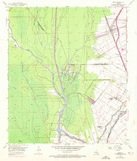
1953 Map of Addis
USGS Topo · Published 1972About this map
Industrial and agricultural development meet at the junction of the Texas and Pacific railroad and the Intracoastal Waterway (Port Allen Canal). The settlement of Addis serves as a transportation hub, while the surrounding landscape transitions from the active Bayou Choctaw Oil Field to the historic grounds of the Myrtle Grove Plantation and Enterprise Plantation. The intricate drainage network of Bayou Grosse Tete and Grand Bayou reflects the complex hydrology of the West Baton Rouge Parish and Iberville Parish border lands.
Find a feature on this map
29 named features on this map. Tap any name to fly to it.
Don’t see what you’re looking for? This feature index may not catch every label — zoom into the map to look around manually.
Map Details
Editions of this 1953 Addis Map
5 editions found

Other maps of this area

1908 · Baton Rouge
USGS Topo · 1:62,500

1935 · Chicot Lake
USGS Topo · 1:62,500

1936 · White Castle
USGS Topo · 1:62,500

1939 · Baton Rouge
USGS Topo · 1:62,500

1940 · Grosse Tete
USGS Topo · 1:62,500

1953 · Baton Rouge West
USGS Topo · 1:24,000

1953 · Crescent
USGS Topo · 1:24,000

1953 · Plaquemine
USGS Topo · 1:24,000

1953 · Lobdell
USGS Topo · 1:24,000

1953 · Pigeon Bay
USGS Topo · 1:24,000