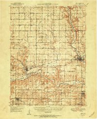
1951 Map of Adel
USGS Topo · Published 1951About this map
The North Raccoon River, Middle Raccoon River, and South Raccoon River converge across this Dallas County landscape, shaping the development of mid-century central Iowa. At the intersection of rail and river, Adel serves as a primary hub, while the Chicago Milwaukee St Paul and Pacific railroad links smaller agricultural sidings and towns like Redfield, Kennedy, and De Soto. The map reveals a high density of rural social infrastructure, from the Friends Church and Washington Chapel to a numbered school system including School No 6 and School No 8. Genealogists will find significant detail in the numerous burial grounds documented, such as Oakdale Cemetery and Wiscotta Cemetery, which reflect the early settlement patterns of townships like Lincoln and Washington.
Find a feature on this map
70 named features on this map. Tap any name to fly to it.
Don’t see what you’re looking for? This feature index may not catch every label — zoom into the map to look around manually.
Map Details
Editions of this 1951 Adel Map
2 editions found
Other maps of this area

1908 · Waukee
USGS Topo · 1:62,500

1911 · Madrid
USGS Topo · 1:62,500

1914 · Madrid
USGS Topo · 1:62,500

1949 · Adel
USGS Topo · 1:62,500

1950 · Perry
USGS Topo · 1:62,500

1951 · Perry
USGS Topo · 1:62,500

1951 · Adel
USGS Topo · 1:62,500

1951 · St. Charles
USGS Topo · 1:62,500

1952 · Panora
USGS Topo · 1:62,500

1952 · Winterset
USGS Topo · 1:62,500