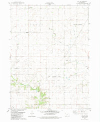
1982 Map of Adel NW
USGS Topo · Published 1983About this map
Lincoln and Linn townships reveal a landscape dominated by the agricultural and industrial infrastructure of central Iowa in the early 1980s. The map illustrates a transition from traditional rural landmarks, like the Shiloh Bible Ch and West Linn Cem, to modern utility systems. A significant Gas Storage Area and a nearby Compressor Station underscore the area's role in regional energy distribution.
Find a feature on this map
16 named features on this map. Tap any name to fly to it.
Don’t see what you’re looking for? This feature index may not catch every label — zoom into the map to look around manually.
Map Details
Editions of this 1982 Adel NW Map
This is the sole edition of this map. No revisions or reprints were ever made.
Other maps of this area

1949 · Adel
USGS Topo · 1:62,500

1950 · Perry
USGS Topo · 1:62,500

1951 · Perry
USGS Topo · 1:62,500

1951 · Adel
USGS Topo · 1:62,500

1952 · Panora
USGS Topo · 1:62,500

1954 · Bagley
USGS Topo · 1:62,500

1954 · Omaha
USGS Topo · 1:250,000

1957 · Omaha
USGS Topo · 1:250,000

1958 · Omaha
USGS Topo · 1:250,000
1982 · Panther
USGS Topo · 1:24,000